Location Image

Dumfries and Galloway

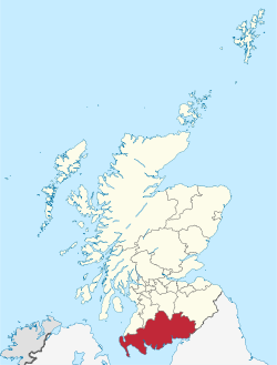
Le Dumfries and Galloway est une council area et une ancienne région d'Écosse, qui couvre la partie ouest des Southern Uplands, dans le sud de l'Écosse, avec pour siège la ville de Dumfries. C'est une région de collines et de prairies avec des exploitations agricoles rentables. Le Galloway Forest Park est pratiquement le seul endroit d'Écosse où la forêt a été réimplantée à grande échelle. La presqu'île des Rhinns of Galloway, au sud-ouest, est plus tournée vers la mer. Stranraer est le port d'où l'on embarque pour l'Irlande du Nord. Le rivage est par endroits constitué de falaises impressionnantes où les vagues viennent se briser les jours de mer forte. Le point le plus au sud de l'Écosse, le Mull of Galloway se trouve dans le district, plus précisément dans le Wigtownshire. Dumfries (env. 32 000 habitants) est un centre de tourisme où le souvenir du poète Robert Burns est très présent. La circonscription administrative régionale a été créée le 15 mai 1975 par la fusion de trois comtés traditionnels : le Dumfriesshire, le Kirkcudbrightshire (aussi connu comme le Stewartry of Kirkcudbright) et le Wigtownshire. Les deux derniers comtés formaient la région historique de Galloway. La région a existé jusqu'au 31 mars 1996 où elle fut remplacée par un council area qui recouvre exactement la même zone géographique. Quand elle était une région, elle était divisée en 4 districts :

Nearby Places View Menu
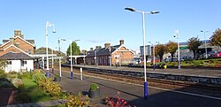
Location Image
4 m

Dumfries

Dumfries (Scots: dum-FREESS; from Scottish Gaelic: Dùn Phris Scottish Gaelic pronunciation: [ˌt̪un ˈfɾʲiʃ]) is a market town and former royal burgh in Dumfries and Galloway, Scotland, near the mouth of the River Nith on the Solway Firth, 25 miles (40 km) from the Anglo-Scottish border. Dumfries is the county town of the historic county of Dumfriesshire. Before becoming King of Scots, Robert the Bruce killed his rival John Comyn III of Badenoch at Greyfriars Kirk in the town in 1306. The Young Pretender had his headquarters here towards the end of 1745. In World War II, the Norwegian armed forces in exile in Britain largely consisted of a brigade in Dumfries. Dumfries is nicknamed Queen of the South. This is also the name of the town's football club. People from Dumfries are known colloquially in Scots language as Doonhamers.
230 m

Greyfriars, Dumfries

Greyfriars, Dumfries, was a friary of the Friars Minor, commonly known as the Franciscans, established in Dumfries, Scotland. Following dissolution the friary was demolished and the site levelled. The locality has retained a reference to the friary in the street named "Friars Vennel". The present neo-Gothic Greyfriars was built from 1868 and is located at the site of the former Maxwell's Castle at the top of High Street. The original friary is best known as where John "the Red" Comyn was killed by Robert the Bruce and his supporters, at the high altar in the chapel. The killing sparked the resumption of conflict with England with Bruce crowned King of Scots at Scone Palace seven weeks later. Bruce's campaign for an independent Scotland reached its culmination when the English recognised Scotland as an independent nation in the Treaty of Edinburgh–Northampton signed in 1328.
Location Image
233 m

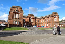
County Buildings, Dumfries

County Buildings is a municipal structure in English Street, Dumfries, Scotland. The structure, which is the headquarters of Dumfries and Galloway Council, is a Category B listed building.
Location Image
309 m

Loreburn Hall

The Loreburn Hall is a military installation in Dumfries, Scotland.
Location Image
325 m

Dumfries railway station

Dumfries railway station serves the town of Dumfries in Dumfries and Galloway, Scotland. It is located on the Glasgow South Western Line. The station is owned by Network Rail and managed by ScotRail who provide all passenger train services. It is staffed on a part-time basis throughout the week.