Location Image

Arn Gill (North Yorkshire)

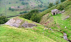
Arn Gill is a ravine or gully containing a beck of the same name, near the village of Muker in Swaledale, North Yorkshire, England. The ravine and beck run steeply downhill from the stream's source in Arn Gill Head, and the beck disgorges into the River Swale below. The ravine contains remnants of the former Adelaide Level lead mine, which is named after Lady Adelaide Lamont, a descendant of Judge Jeffreys. In 1865 a strike was made there, which yielded about £12,000 (equivalent to £1,449,217 in 2023) worth of galena or lead ore. The mine closed in 1920. Miners worked in bad conditions in North Yorkshire lead mines during the Adelaide Level's era, with over 62% of local mines having extremely impure air. The most common occupational disease for miners was silicosis.

Nearby Places View Menu
Location Image
1.2 km

Kisdon

Kisdon, also called Kisdon Hill, is a fell situated in upper Swaledale in the Yorkshire Dales National Park in North Yorkshire, England.
Location Image
1.4 km

Muker

Muker is a village and civil parish at the western end of Swaledale in North Yorkshire, England, within the Yorkshire Dales. The parish includes the hamlets and villages of Angram, Keld, Thwaite, West Stonesdale and Birkdale, as well as the Tan Hill Inn, the highest in England. At the 2001 census the civil parish had a population of 309, reducing to 249 at the 2011 census. In 2015, North Yorkshire County Council estimated the population to be 260. From 1974 to 2023 it was part of the district of Richmondshire, it is now administered by the unitary North Yorkshire Council.
Location Image
1.8 km

Angram Bottoms

Angram Bottoms (grid reference SD891999) is a 9.8 hectares (24 acres) biological Site of Special Scientific Interest (SSSI) near to the village of Angram in the Yorkshire Dales, England. The SSSI was first notified in 1989 and is due to the wet and dry grassland habitats which are unusual in the Yorkshire Dales.
Location Image
1.9 km

Thwaite, North Yorkshire

Thwaite is a small village in the Yorkshire Dales, North Yorkshire, England. It is in Swaledale and is part of the civil parish of Muker. The village lies on the B6270 road that runs through Swaledale from east to west and is 9.3 miles (15 km) west of Reeth. The name "Thwaite" comes from the Old Norse word þveit, meaning 'clearing, meadow or paddock'. From 1974 to 2023 it was part of the district of Richmondshire, it is now administered by the unitary North Yorkshire Council.