
 English
 Français
Blea Rigg
Blea Rigg is a fell in the English Lake District, lying between the valleys of Easedale and Great Langdale. One of the Central Fells, it is a broad plateau with a succession of rocky tops. Many routes of ascent are possible, beginning either from Grasmere or Great Langdale, though the paths are often poorly marked and hard to follow.
Nearby Places View Menu
1.1 km
Easedale Tarn
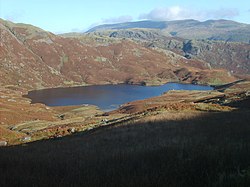
Easedale Tarn is a tarn in the centre of the English Lake District, about two miles west of the village of Grasmere. It lies in a hollow between Tarn Crag to the north and Blea Rigg to the south, about 910 feet or 280 metres above sea level. The hollow was formed by a small corrie glacier, and is believed to have filled with water around 11,000 years ago when the ice finished melting.
Easedale Tarn is one of the larger tarns in the district, about 480 metres (1,570 ft) long and 300 metres (980 ft) wide. Its outflow is Sourmilk Gill, named after the milky white colour of its waterfalls, which runs east towards Grasmere. The gill displays impressive water scenery when seen from Grasmere, and from the path to the tarn.
The tarn is a popular destination for walkers. Many people climb the path from Grasmere which overlooks Sourmilk Gill. The ascent was popular during the Victorian period, and a refreshment hut was even established in the 19th century by Robert Hayton of Grasmere above the outlet of the tarn to service the thirsty visitors. The hut is long gone, and nettles now grow where the ruins used to be.

1.3 km
Great Langdale
Great Langdale is a valley in the Lake District National Park in North West England, the epithet "Great" distinguishing it from the neighbouring valley of Little Langdale. Langdale is also the name of a valley in the Howgill Fells, elsewhere in Cumbria.
It is a popular location for hikers, climbers, fell-runners and other outdoor enthusiasts who are attracted by the many fells ringing the head of the valley. Among the best-known features of Great Langdale are the Langdale Pikes, a group of peaks on the northern side of the dale. England's highest mountain, Scafell Pike, can be climbed by a route from Langdale. Langdale has views of, in particular, Dungeon Ghyll Force waterfall, Harrison Stickle and Pike of Stickle.
Great Langdale was an important site during the Neolithic period for producing stone axes and, later, was also one of the centres of the Lakeland slate industry.

1.4 km
Tarn Crag (Easedale)
Tarn Crag is a fell in the Central Fells of the English Lake District. Strictly the name refers only to the rock face looking down upon Easedale Tarn, but Alfred Wainwright applied it to the entire ridge lying between the Easedale and Far Easedale valleys in his Pictorial Guide to the Lakeland Fells

1.6 km
Stickle Tarn, Langdale
Stickle Tarn is a small tarn near Harrison Stickle in Lake District, England. The tarn was enlarged by the building of a stone dam in 1838 and is used to supply water for the inhabitants of Langdale. The tarn is situated in a corrie, flanked on the west side by Harrison Stickle, and on the north by the massive imposing bulk of Pavey Ark's south face. The tarn is frequently visited by fellwalkers ascending to Pavey Ark's summit, or en route to High Raise from Great Langdale.
In February 2015 it was put up for sale by the Lake District National Park Authority, which was seeking to reduce its landholdings in the national park.
The walk from Langdale to Stickle Tarn is one of the most popular in the Lake District, and short enough to be a relatively easy outing for families.