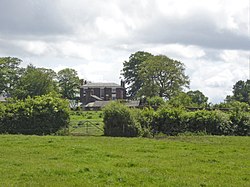
Bostock Hall is a country house to the northeast of Winsford, Cheshire, England. A former Georgian house, it was rebuilt in 1775 for Edward Tomkinson. It is thought that the architect was Samuel Wyatt. Alterations and additions were made to it in the middle of the 19th century and in 1875. The house is constructed in brick with ashlar dressings; it has a slate roof. It is in three storeys plus a basement. Its plan is L-shaped. The entrance front has a central bow window rising through all floors, and a single-storey porch with a balustraded parapet. The garden front has two bows, between which are a Venetian window with a Diocletian window above. The house is recorded in the National Heritage List for England as a designated Grade II* listed building.

1. See also

Grade II* listed buildings in Cheshire West and Chester Listed buildings in Bostock

1. References


1. Further reading
Nearby Places View Menu
Location Image
530 m

Bostock, Cheshire

Bostock is a village in the unitary authority of Cheshire West and Chester and the ceremonial county of Cheshire, England. Bostock was a separate civil parish until 2023, when it merged with Davenham parish. According to the 2001 census Bostock had a population of 229, reducing slightly to 225 at the 2011 Census. The village is between the towns of Winsford and Northwich.
1.6 km

Whatcroft Hall

Whatcroft Hall is a country house situated 1.5 miles (2.4 km) to the southeast of the village of Davenham, Cheshire, England. It stands to the east of, and overlooking, the Trent and Mersey Canal. The house is recorded in the National Heritage List for England as a designated Grade II* listed building.
Location Image
1.7 km

Cheshire Plain

The Cheshire Plain is a relatively flat expanse of lowland within the county of Cheshire in North West England but extending south into Shropshire. It extends from the Mersey Valley in the north to the Shropshire Hills in the south, bounded by the hills of North Wales to the west and the foothills of the Pennines to the north-east. The Wirral Peninsula lies to the north-west whilst the plain merges with the South Lancashire Plain in the embayment occupied by Manchester to the north. In detail, the plain comprises two areas with distinct characters, the one to the west of the Mid Cheshire Ridge and the other, larger part, to its east. The plain is the surface expression of the Cheshire Basin, a deep sedimentary basin that extends north into Lancashire and south into Shropshire. It assumed its current form as the ice-sheets of the last glacial period melted away between 20,000 and 15,000 years ago leaving behind a thick cover of glacial till and extensive tracts of glacio-fluvial sand and gravel. The primary agricultural use of the Cheshire Plain is dairy farming, creating the general appearance of enclosed hedgerow fields. Meteorologists use the term Cheshire Gap when referring to the lowlands of the Cheshire Plain, providing as they do a passage between the Clwydian Hills, in Wales on the one hand and the Peak District and South Pennines on the other. Weather systems are often guided down this "gap", penetrating much further inland than elsewhere along the coast of the Irish Sea.
Location Image
1.8 km

Stanthorne Hall

Stanthorne Hall is a country house standing to the west of the village of Stanthorne, Cheshire, England. It was built between 1804 and 1807 for Richard Dutton, who had purchased the estate from the Leicesters of Tabley. The house is constructed of brick with painted stone dressings and a slate roof. It is in three storeys with a symmetrical entrance front of three bays. The doorway is surrounded by Tuscan columns and an open pediment with a fanlight. The windows are sash windows. To the rear is a long wing. Inside the house, the entrance hall contains an open well staircase of three flights, and has a cornice with a frieze containing triglyphs. Two of the ground floor rooms have black marble fireplaces. The house is recorded in the National Heritage List for England as a designated Grade II listed building.