
 English
 Français
Hollinshead Hall
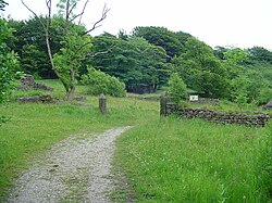
Hollinshead Hall was a manor house close to the village of Tockholes, Lancashire. It is unclear whether the hall was originally the manor house of Tockholes, or if Hollinshead was indeed a manor in its own right alongside Tockholes and Livesey. The ruins of the hall are situated approximately 2 miles (3.2 km) south of the village. The main features of the site consist of the ruins of the late 18th century hall and Gardens, and the associated barn and stables. To the south of here are the remains of the farmhouse and farm buildings, and at the south-east side of the enclosed garden is a well house, the only structure on the site which remains standing today.
Nearby Places View Menu

1.8 km
Roddlesworth
Roddlesworth is a hamlet in the parish of Withnell in Lancashire, England. It lies on the road connecting Preston with Bolton.
The name is first encountered as Rodtholfeswrtha (1160), meaning "the homestead of Hrothwulf".

2.0 km
Great Hill (England)
Great Hill is a hill in Lancashire, England, on Anglezarke Moor, between the towns of Chorley and Darwen. It is part of the West Pennine Moors and lies approximately 3 miles north of Winter Hill, the highest point in the area at 456 m (1,498 ft).
The summit at 381 m (1,252 ft) is only slightly higher than the surrounding moorland, but provides excellent views in all directions particularly to the north and west. Paths head west towards White Coppice via the ruins of Drinkwaters, south to Winter Hill via Hordern Stoops, and east to Darwen Tower via Pimm's, Picadilly and the ruins of Hollinshead Hall.
The sources of Black Brook and the River Roddlesworth are on the slopes of the hill.
The traditional walker's cairn has been replaced by a stone bench in the shape of a cross, which offers shelter from the wind.
2.0 km
Upper Roddlesworth Reservoir
Upper Roddlesworth Reservoir is a reservoir on the River Roddlesworth near Abbey Village in Lancashire, England.
The reservoir is close to Lower Roddlesworth Reservoir and Rake Brook Reservoir and sits within dense woodland.

2.0 km
Black Brook (Chorley)
Black Brook in Lancashire has its source at Great Hill in the West Pennine Moors. The water is acidic due to a high level of peat in the uplands near to Round Loaf, giving the brook its brown colour. The young river was known as Warth Brook in olden Heapey. A feeder stream also known as Black Brook joins near Kittiwake Road - this short and weak water course commences at Eagle Tower. The jointed brook feeds Anglezarke Reservoir, and joins the River Yarrow in lowland Chorley at Yarrow Bridge. The entire course of Black Brook and the River Yarrow fall within Chorley and its villages.