
 English
 Français
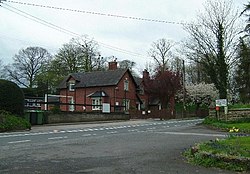
Adderley
Adderley est un village et une paroisse civile du Shropshire, en Angleterre. Il se situe dans le nord-est du comté, à 6 km au nord de la ville de Market Drayton.
Nearby Places View Menu

3.7 km
Audlem Baptist Church
Audlem Baptist Church is in Woore Road, Audlem, Cheshire, England. It is an active Baptist church, and is recorded in the National Heritage List for England as a designated Grade II listed building.

3.8 km
St James' Church, Audlem
St James' Church is in the village of Audlem in south Cheshire, England. It is recorded in the National Heritage List for England as a designated Grade I listed building.
The church dates from the late 13th century with additions in the 19th century. It is an active Anglican parish church in the diocese of Chester, the archdeaconry of Macclesfield and the deanery of Nantwich. Its benefice is combined with those of St John, Doddington, and St Chad, Wybunbury. The church stands in an elevated position in the centre of the village.

3.8 km
Audlem
Audlem ( AWD-ləm) is a village and civil parish in the Cheshire East district of Cheshire, England. In 2021, it had a population of 1,832.
Audlem is approximately 7 miles (11 km) south of Nantwich, 8 miles (13 km) east of Whitchurch and 7 miles (11 km) north of Market Drayton. It is also close to the county border with Shropshire.
4.1 km
Buerton, Cheshire East
Buerton is a village (at SJ685435) and civil parish in the unitary authority of Cheshire East and the ceremonial county of Cheshire, England, about 7 miles south of the town of Nantwich and 1½ miles east of the village of Audlem, on the border with Shropshire. The parish also includes the small settlements of Hankins Heys, Moblake, Pinder's End and Three Wells, as well as parts of Chapel End, College Fields, Kinsey Heath, Longhill, Raven's Bank, Sandyford and Woolfall. In 2001, the total population was a little under 500, which had increased marginally to 503 at the 2011 Census. Nearby villages include Adderley, Audlem, Bridgemere, Hankelow, Hatherton, Hunsterson and Woore.

4.3 km
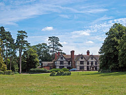
Moss Hall, Audlem
Moss Hall, Audlem, is a manor house 0.5 miles (1 km) north-west of Audlem, Cheshire, England. It is recorded in the National Heritage List for England as a designated Grade I-listed building. The Hall overlooks the Shropshire Union Canal.
Moss Hall was built in 1616 for Hugh Massey, then owned by Edward Legh of Baguley Hall. It is timber-framed with rendered infill, and close studded with a middle rail to both floors. It is in two storeys with attics, and has a plain tile roof. The entrance front has five bays with four gables. The house is nearly symmetrical, is E-shaped, and is set on an ashlar plinth. In its centre is a two-storey gabled porch wing, which is a later addition. The first floor is jettied and supported on carved brackets. It has been described as "a surprisingly complete example of a gentleman's house of the early 17th century".