Location Image

South Pennines Regional Park

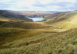
The South Pennines Regional Park (or South Pennines Park) was a proposed national park that would cover the South Pennines area in Northern England, encompassing parts of Greater Manchester, Lancashire and West Yorkshire. It would also adjoin the borders of two existing national parks; the Yorkshire Dales in the north and the Peak District in the south. The area was named as a prospective national park in the 1940s when the idea of creating national parks was being carried forward, but it was never given the same status as the Peak District, North York Moors or the Yorkshire Dales. The South Pennines Regional Park was championed by many agencies and charities. Pennine Prospects were awarded Heritage Lottery Funding in 2018. In September 2021, the park was launched under a "self-declaration" scheme, though its status is not recognised by the Department for Environment, Food and Rural Affairs. The organisation behind the proposal closed at the end of 2023. The South Pennines is the only upland area of England without any designated protection framework.

Nearby Places View Menu
Location Image
1.2 km

Eastwood (L&Y) railway station

Eastwood Railway Station served the village of Eastwood in the civil parish of Todmorden, West Yorkshire, England. The station opened with the line on New Years Day 1841 and was closed on 3 December 1951 by British Railways. Retaining walls in the cliff above the site, together with a substantial road access ramp, and the remains of adjacent coal drops can still be seen. In addition, the former vehicle-size level crossing has survived in reduced form, as a pedestrian crossing. The signal box here survived for around 20 more years until its abolition as part of the Preston area resignalling scheme in 1972. A derailment in the (now removed) goods loop next to the westbound line in October 1986 blocked the route for over a week — heavy lifting equipment had to be brought in to recover several overturned coal hopper wagons from the scene, whilst a replacement bus service ran between Todmorden and Hebden Bridge stations.
Location Image
1.4 km

Eastwood, West Yorkshire

Eastwood is a place within the civil parish of Todmorden and Metropolitan Borough of Calderdale, in West Yorkshire, England. It lies 8 miles (12.9 km) west from Halifax, roughly equidistant from Todmorden's town centre, which is 2 miles (3.2 km) to the southwest, and Hebden Bridge, which is 2 miles to the northeast, along the course of the River Calder. Eastwood falls within the Calder ward of Calderdale council. Historically a part of the West Riding of Yorkshire, sources suggest that Eastwood's name was almost certainly taken from the Eastwoode family, who were local landowners active from the 13th to 17th centuries. Eastwood Old Hall is the former seat of this family, and remains as a landmark and manorhouse within the locality
Location Image
1.4 km

Colden, West Yorkshire

Colden is a hamlet in the civil parish of Heptonstall in Calderdale, West Yorkshire, England. Historically part of the West Riding of Yorkshire, the hamlet consists of scattered houses and farms on high ground west of Heptonstall, above the valley of Colden Water. Colden School is a junior and infants school established in 1878. Colden Water is crossed by two old footbridges, possibly dating from the 17th century. Strines Bridge is a packhorse bridge, and lower down a clapper bridge crosses the stream. Both are Grade II listed buildings. The Pennine Way and Calderdale Way both pass through Colden.
Location Image
1.7 km

Blackshaw

Blackshaw is a civil parish in the Calderdale metropolitan borough of West Yorkshire, England. It contains the village of Blackshaw Head. According to the 2001 census, the parish had a population of 935, increasing to 992 at the 2011 Census.