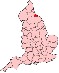
Cleveland (pron.: [ˈkliːvlənd]) est une ancienne zone géographique dans le Nord-Est de l’Angleterre. Son nom, « cliff-land », se réfère aux collines de sa partie méridionale, qui atteignent 450 m d'altitude. Historiquement intégrée dans le North Riding of Yorkshire, Cleveland se situe au sud de la Tees, et sa plus grosse agglomération a été Guisborough, jusqu'à ce que Middlesbrough ne la dépasse au cours du XIXe siècle. En 1974, un comté non-métropolitain est créé par le Local Government Act 1972, et nommé d'après la région historique, bien qu'il ne la couvre pas entièrement et qu'il intègre une zone au nord de la Tees qui faisait jusqu'ici partie du comté de Durham. Ce comté s'organise autour de la zone urbaine de Teesside et concerne Middlesbrough, Stockton-on-Tees, Hartlepool et Redcar. En 1996, le comté est supprimé, ses arrondissements devenant une unitary authority et la Tees redevenant la frontière entre le Yorkshire du Nord et le comté de Durham pour les usages cérémoniaux.

1. Notes et références


1. = Notes =


1. = Références =


1. Bibliographie

(en) Local government in England and Wales : A Guide to the New System, Londres, HMSO, 1974, 275 p. (ISBN 0-11-750847-0), p. 37 Portail de l’Angleterre

Nearby Places View Menu
Location Image
2.5 km

St Michael and St George's Church, Castleton

St Michael and St George's Church is an Anglican church in Castleton, North Yorkshire, a village in England. The first church in Castleton was constructed in 1865, with funding from Viscountess Downe and Lydia Dawnay. It was an iron building, which served as a chapel of ease to St Hilda's Church, Danby. A new church was completed in 1924, on the initiative of the Reverend Sydney Smith. It was designed by Leslie Moore, and funded in part by a grant of £150 from the Incorporated Church Building Society. The building was grade II listed in 1969. The church is built of sandstone with a green slate roof, and consists of a nave with a south porch, a chancel with a north vestry, and a west tower. The tower has two stages, the upper stage stepped-in, buttresses, a west doorway with a pointed arch, two and three-light bell openings, and an embattled parapet. The interior is plastered, with some exposed stone dressings. The chancel and tower arches both have carved wooden screens, and the sanctuary is panelled, with a reredos painting depicting the church's patron saints. There is a hexagonal stone font.
Location Image
2.6 km

Castleton Moor railway station

Castleton Moor is a railway station on the Esk Valley Line, which runs between Middlesbrough and Whitby via Nunthorpe. The station, situated 16 miles 45 chains (26.7 km) west of Whitby, serves the village of Castleton in North Yorkshire, England. It is owned by Network Rail and managed by Northern Trains.
Location Image
2.7 km

Castleton, North Yorkshire

Castleton is a village on the River Esk, part of the civil parish of Danby in the county of North Yorkshire in England, 7.1 miles (11.5 km) south-east of Guisborough, in the North York Moors. There was once a medieval castle on Castle Hill that is thought to have been abandoned when Danby Castle was constructed. Castleton has a local school, St Michael and St George's Church. Castleton is a centre for walking, birdwatching, shooting and many other pursuits. It is said that Castleton was named after a castle built near the River Esk. The village has a Clapper bridge that spans Danby Beck; this bridge was listed as Grade II in 2016. Castleton has a primary school (Castleton Community Primary School) with secondary education available at Caedmon College or Eskdale School, which are both in Whitby. Castleton was once the main market and industrial town serving Upper Eskdale. There were annual wool, cheese and cattle fairs, cheese market and a silk mill.
3.6 km

Pinkney and Gerrick Woods

Pinkney And Gerrick Woods (grid reference NZ708138) is a 62.7 hectare biological Site of Special Scientific Interest in North Yorkshire, England notified in 1954. SSSIs are designated by Natural England, formally English Nature, which uses the 1974–1996 county system. This means there is no grouping of SSSIs by Redcar and Cleveland unitary authority, or North Yorkshire which is the relevant ceremonial county. As such Pinkney and Gerrick Woods is one of 18 SSSIs in the Cleveland area of search.
Location Image
3.8 km

Commondale railway station

Commondale is a railway station on the Esk Valley Line, which runs between Middlesbrough and Whitby via Nunthorpe. The station, situated 16 miles 72 chains (27.2 km) south-east of Middlesbrough, serves the village of Commondale in North Yorkshire, England. It is owned by Network Rail and managed by Northern Trains.