
 English
 Français

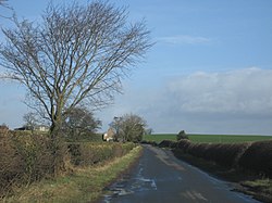
Hornby (Richmondshire)
Hornby est un village et une paroisse civile du Yorkshire du Nord, en Angleterre.
Nearby Places View Menu

1.2 km
Arbour Hill, Hornby
Arbour Hill is a historic building in the parish of Hornby, near Bedale in North Yorkshire, in England.
The building was commissioned as one of four model farms by Robert Darcy, 4th Earl of Holderness of Hornby Castle. It was designed by John Carr, its composition inspired by his earlier farm, Street House in Ainderby Miers, and was completed in about 1760. It was grade II listed in 1967. One of its barns was converted into accommodation in the 1980s, then in 2010 the house was restored along with its outbuildings. The dovecote and summerhouse flanking the house were converted into holiday accommodation.
The house is built of sandstone on a plinth, with an impost band, an eaves band, and pantile roofs. The house has two storeys and seven bays, the middle three bays projecting and canted, and the outer bays are three-storey pavilions with pyramidal roofs. The house is flanked by screen walls, each containing a doorway. To the left is a two-storey dovecote, and to the right is a two-storey summerhouse, both with a pyramidal roof. The windows in the house are sashes, and in each pavilion is an oculus. Inside the house is an 18th-century staircase.
1.8 km
Appleton East and West
Appleton East and West is a civil parish in the county of North Yorkshire, England. It contains the villages East Appleton and West Appleton, and had a population of 76 according to the 2001 census, remaining at less than 100 in the 2011 Census. From this date population details are maintained within the parish of Hornby. The settlement consists of two farms, with several water bodies in the area.
From 1974 to 2023 it was part of the district of Richmondshire, it is now administered by the unitary North Yorkshire Council.
In the 1870s, Appleton East and West was described as
"A township in Catterick parish, N. R. Yorkshire; 5½ miles SE of Richmond. Acres, 1,583. Real property, £2,812. Pop., 115. Houses, 16"

2.1 km
Arrathorne
Arrathorne is a hamlet and civil parish in the county of North Yorkshire, England. The settlement is 6 miles (9 km) south of Richmond, 6 miles (9 km) north-west of Bedale and 6 miles (9 km) east of Leyburn. The name has been recorded variously as Ergthorn, Erchethorn, Erghethorn, Erethorn and Arrowthorne. It means The Thornbush by the Shieling. Historically, the hamlet was in the Parish of Patrick Brompton in the Wapentake of Hang East.
From 1974 to 2023 it was part of the district of Richmondshire, it is now administered by the unitary North Yorkshire Council.
The nearest city to Arrathorne is Ripon. According to the 2001 census it had a population of 61. The population in 2011 census was 90 with an estimated population of the same number in 2015. It has neither pub nor public telephone box and is not on a bus route. The nearest bus stop is in Hunton, just over a mile away. The nearest national rail station on the East Coast Main Line is in Northallerton 11 miles (18 km) away.
There is one recorded descriptive gazetteer entry, in John Bartholomew's Gazetteer of the British Isles, "Arrathorne, township, North-Riding Yorkshire, 5 miles NE. of Leyburn, 671 ac., pop. 62."
2.2 km
Hackforth
Hackforth is a small village and civil parish in the county of North Yorkshire, England, about 4 miles (6 km) north of Bedale. Nearby settlements include Langthorne and Crakehall.

2.4 km
Tunstall, North Yorkshire
Tunstall is a village and civil parish in the county of North Yorkshire, England about 2 miles (3.2 km) west of Catterick Village and the A1(M) motorway. It had a population of 253 increasing to 271 at the 2011 census.