
 English
 Français

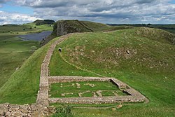
Milecastle 38
Milecastle 38 (Hotbank) was a milecastle on Hadrian's Wall in the vicinity of Hotbank Farm, (grid reference NY77276813). It is notable for the joint inscription bearing the names of the emperor Hadrian and Aulus Platorius Nepos, the governor of Britannia at the time the Wall was built.
Nearby Places View Menu
600 m
Crag Lough
Crag Lough is an inland lake at the southern edge of Northumberland National Park, 2.5 miles (4.0 km) north of Bardon Mill, and 0.5 miles (0.8 km) north of the B6318 Military Road in Northumberland, northern England. At this point Hadrian's Wall is at the top of a line of crags, the Whin Sill, with Crag Lough at the foot of the crags.

1.2 km
Sycamore Gap tree
The Sycamore Gap tree, also known as the Robin Hood tree, was a 120-year-old sycamore tree next to Hadrian's Wall near Crag Lough in Northumberland, England. It was illegally felled in 2023 by Daniel Graham and Adam Carruthers, but has since sprouted from the stump. Standing in a dramatic dip in the landscape created by glacial meltwater, it was one of the country's most photographed trees and an emblem for the North East of England. It derived its alternative name from featuring in a prominent scene in the 1991 film Robin Hood: Prince of Thieves. The tree won the 2016 England Tree of the Year award, part of the Woodland Trust's annual competition that celebrates culturally and environmentally significant trees across the UK. As the national winner for England, the Sycamore Gap tree received a £1,000 care grant funded by the People's Postcode Lottery.
The tree was illegally felled in the early morning of 28 September 2023. Northumbria Police described the felling of the tree as "an act of vandalism". Two men from Cumbria, aged 38 and 31, were arrested in October 2023 and charged in April 2024 with criminal damage both to the tree and to the adjacent Hadrian's Wall. Their trial began on 28 April 2025 at Newcastle Crown Court and they were found guilty on 9 May. Both men were sentenced to 4 years and 3 months in prison on 15 July 2025.
The stump has thrown up basal shoots and is still alive, albeit severely coppiced; the tree is expected to take more than 150 years to recover. Cuttings were also gathered from the tree.
1.3 km
Milecastle 39
Milecastle 39 (Castle Nick) is a milecastle on Hadrian's Wall (grid reference NY76066773).

1.8 km
Limes Britannicus
The frontier of the Roman Empire in Britain is sometimes styled Limes Britannicus ("British Limes") by authors for the boundaries, including fortifications and defensive ramparts, that were built to protect Roman Britain (the term Limes is mainly and originally used for the Roman frontier in the Germanic provinces). These defences existed from the 1st to the 5th centuries AD and ran through the territory of present-day England, Scotland and Wales.
Britain was one of the most troubled regions in the European part of the Roman Empire and could only be secured by the Roman Army at considerable effort. Despite a rapid victory over the tribes in the south, which Claudius' field commander, Aulus Plautius, achieved in 43 AD for Rome, the resistance of the British was not completely broken for a long time afterwards. Nevertheless, the Romans succeeded in further consolidating their rule in the period that followed, although the troops stationed there were overburdened by having to defend Britain simultaneously on three fronts. The incursions of barbarians from the north of the island repeatedly caused serious problems. To the west and south, the Britannic provinces had to be defended against Hibernian and Germanic attacks. Rome held the province for three and a half centuries. Behind the protection of Hadrian's Wall and that formed by the natural coastal boundaries to the east, south and west, the region we now know as England was heavily influenced by Roman civilisation. Hadrian's Wall and the castra on the Saxon Shore are still the most prominent symbols of Roman rule over Britain.