
 English
 Français

Copley railway station
Copley railway station was a railway station that served the village of Copley in West Yorkshire, England.
Nearby Places View Menu

335 m
Copley, West Yorkshire
Copley is a village in the metropolitan borough of Calderdale, in the county of West Yorkshire, England, south of Halifax and east of Sowerby Bridge. It is situated by the River Calder and the Calder and Hebble Navigation canal.

393 m
Skircoat Green
Skircoat Green () is an area to the south of Halifax, West Yorkshire, England. Skircoat is a ward of the Borough of Calderdale whose population at the 2011 Census was 12,712.
In the 13th century, the land was granted to the Earl Warren, and then passed to the Savile family. This was an independent township before being absorbed by the Borough of Halifax in 1892. The name was originally Schircotes and means building on the rocks. The Skircoat Green Area of Halifax is north of Salterhebble and is one of the most expensive areas of Halifax.

481 m
St Stephen's Church, Copley
St Stephen's Church is a redundant Anglican church in the village of Copley, West Yorkshire, England. It is recorded in the National Heritage List for England as a designated Grade II* listed building, and is under the care of the Churches Conservation Trust.
917 m
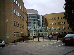
Calderdale Royal Hospital
The Calderdale Royal Hospital is a hospital situated in the English town of Halifax. It is located in the suburb of Salterhebble and provides general services, emergency services and some specialist services including coronary care and the Calderdale and Huddersfield area maternity unit. It is managed by Calderdale and Huddersfield NHS Foundation Trust.