
 English
 Français
Church Street, Warrington
Church Street is one of the main thoroughfares of Warrington in Cheshire, England, linking the modern town centre to St Elphin's Church, to the east.
Nearby Places View Menu

216 m
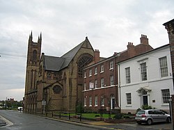
St Elphin's Church, Warrington
St Elphin's Church is the parish church of the town of Warrington, Cheshire, England. The church is recorded in the National Heritage List for England as a designated Grade II* listed building. It is an active Anglican parish church in the diocese of Liverpool, the archdeaconry of Warrington and the deanery of Warrington.
393 m
St Mary's Church, Warrington
St Mary's Church, or St Mary's Priory, is in the town centre of Warrington, Cheshire, England. It is recorded in the National Heritage List for England as a designated Grade II listed building, and is an active Catholic church. The parish was established and served by Benedictine monks from Ampleforth Abbey, but following the withdrawal of Ampleforth Abbey from the parish in 2012, it was served by the priest from St Benedict's Church, Warrington. From November 2015, the church has been owned and served by priests from the Priestly Fraternity of Saint Peter (FSSP) as a shrine church dedicated to the celebration of the sacraments of the pre-Vatican II form of the Roman Rite. It is well known for the beauty and reverence of its liturgy.
Since summer 2017, Sunday Sung Mass and daily Low Mass are streamed live and on-demand from St Mary's at LiveMass.net and via the iMass app.

458 m
Howley Bridge
The Howley Bridge is a pedestrian footbridge which spans the River Mersey in Warrington, England. It connects Howley in Warrington to Victoria Park in Latchford.
The bridge was constructed in 1912 (1912) by the London-based David Rowell & Co. It is a suspension bridge, constructed primarily of wrought iron with steel suspension cables and a timber-planked walkway.
The bridge is similar in construction, appearance and properties to other bridges made by the company, such as Daly's Bridge. The Howley Bridge also shares the shakiness for which Daly's Bridge is known.
The bridge received maintenance during the construction of the Warrington Flood defences.
The bridge is a registered Grade II listed building.

464 m
Warrington
Warrington () is an industrial town in Cheshire, England. The town is the main settlement of the Borough of Warrington and sits on the banks of the River Mersey and was historically part of Lancashire. It is 16 miles (26 km) east of Liverpool and 16 miles (26 km) west of Manchester.
The population in 2021 was recorded as 174,970 for the built-up area and 210,900 for the wider borough, the latter being more than double that of 1968 when it became a new town. Warrington is the largest town in the ceremonial county of Cheshire.
Warrington was founded by the Romans at an important crossing place on the River Mersey. A new settlement was established by the Saxon Wærings. By the Middle Ages, Warrington had emerged as a market town at the lowest bridging point of the river. A local tradition of textile and tool production dates from this time.
The expansion and urbanisation of Warrington coincided with the Industrial Revolution, particularly after the Mersey was made navigable in the 18th century. The West Coast Main Line runs north to south through the town, and the Liverpool to Manchester railway (the Cheshire Lines route) west to east. The Manchester Ship Canal cuts through the south of the borough (west to east). The M6, M56 and M62 motorways form a partial box around the town and are all accessible through Warrington.
The modern Borough of Warrington was formed in 1974 with the amalgamation of the former County Borough of Warrington, part of the Golborne Urban District, the Lymm Urban District, part of the Runcorn Rural District, the Warrington Rural District and part of the Whiston Rural District.