
 English
 Français

Burland (Cheshire)
Burland est un village d'Angleterre située dans le comté de Cheshire et une paroisse civile de la Crewe et Nantwich. La branche de Llangollen du Shropshire Union Canal passe à l'est du village.
Nearby Places View Menu

40 m
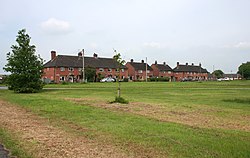
Burland
Burland is a village and former civil parish, now in the parish of Burland and Acton, in the unitary authority area of Cheshire East and the ceremonial county of Cheshire, England, about 2+1⁄2 miles west of Nantwich. The civil parish also included the small settlements of Burland Lower Green, Burland Upper Green, Hollin Green and Stoneley Green, as well as parts of Gradeley Green and Swanley. The eastern part of the village of Ravensmoor also falls within the civil parish (also in the parish of Baddiley).
According to the 2001 census the civil parish had a total population of 582, decreasing slightly to 580 at the 2011 Census.

1.3 km
Snugburys
Snugburys is an English ice cream manufacturer based at Park Farm in Hurleston, near Nantwich, in the county of Cheshire. Snugburys makes over 35 flavours of ice cream. In addition to ice cream production, Snugburys also regularly produces large sculptures made of steel-reinforced straw.

1.4 km
Hurleston
Hurleston was a civil parish until April 2023, and now forms part of the civil parish of Stoke and Hurleston, situated to the north-west of Nantwich. It lies within the unitary authority area of Cheshire East and the ceremonial county of Cheshire, England. The area is predominantly rural with scattered farms and buildings and no settlements. Nearby villages include Barbridge, Burland, Radmore Green, Rease Heath and Stoke Bank.
According to the 2001 census, the parish had a population of 64. At the 2011 Census, the population remained under 100. Details are included in the civil parish of Stoke. In 2021 it was 75.

1.7 km
Ravensmoor Windmill
Burland Windmill is a former windmill located to the south of Wrexham Road (A534) between the villages of Acton and Burland, Cheshire, England. It is recorded in the National Heritage List for England as a designated Grade II listed building. The structure dates from the early 19th century, and is constructed in red brick. It consists of a circular tapering tower with a boarded roof. The original roof and sails are no longer present, and water pumping mechanism has been installed on the roof. There are windows on three levels, some of which are blocked.
1.8 km
Brindley
Brindley is a village (at SJ592534) and civil parish in Cheshire, England. The village lies 3¾ miles to the west of Nantwich. The parish also includes the settlements of Brindley Lea, Ryders Bank and part of Radmore Green, with a total population of about 150. Nearby villages include Barbridge, Burland, Haughton and Faddiley.