
 English
 Français
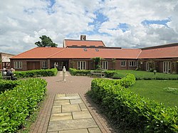
Thicket Priory
Thicket Priory is a religious house in the civil parish of Thorganby, North Yorkshire, England, located about 7 miles (11.3 km) south-east of York. It lies in the Roman Catholic Diocese of Middlesbrough.
Nearby Places View Menu

867 m
Pocklington Beck
Pocklington Beck is a watercourse that flows westwards from Pocklington in the East Riding of Yorkshire, and empties into the River Derwent at East Cottingwith. The beck is known for being culverted through the town of Pocklington, and for being susceptible to flooding. Historically the beck supported the villages along the route by providing water-power for several corn mills.

1.3 km
East Cottingwith
East Cottingwith is a village and former civil parish, now in the parish of Cottingwith, in the East Riding of Yorkshire, England. It lies on the former Derwent Navigation (canal), and approximately 9 miles (14 km) north-west of the market town of Howden and 7 miles (11 km) south-west of the market town of Pocklington. The village is 1 mile (1.6 km) west of the B1228 road and just east of the River Derwent. In 1931 the civil parish had a population of 185. East Cottingwith was formerly a township and chapelry in the parish of Aughton, from 1866 East Cottingwith was a civil parish in its own right, on 1 April 1935 the civil parish was merged with Storwood to create Cottingwith.
The civil parish of Cottingwith is formed by the village of East Cottingwith and the hamlet of Storwood.
According to the 2011 UK Census, Cottingwith parish had a population of 349, an increase on the 2001 UK Census figure of 290.
The village church is St Mary's and is a Grade II listed building.
The name Cottingwith derives from the Old English Cottingwīc meaning the 'trading settlement connected with Cott' or 'Cotta'. Wīc was replaced by the Old Norse vithr meaning 'wood' later on.

1.6 km
Thorganby, North Yorkshire
Thorganby is a small village and civil parish in North Yorkshire, England. It was historically part of the East Riding of Yorkshire until 1974, but from 1974 to 2023 was in the Selby District of the shire county of North Yorkshire. In 2023 the district was abolished and North Yorkshire became a unitary authority.
It is situated 3 miles (4.8 km) from the village of Wheldrake. According to the 2011 census the village had 330 residents. Children in the village attend Wheldrake with Thorganby C of E (Aided) Primary School, located in Wheldrake.

1.7 km
Storwood
Storwood is a hamlet and former civil parish, now in the parish of Cottingwith, East Riding of Yorkshire, England. It is situated approximately 6 miles (9.7 km) south-west of Pocklington and lies to the south of the B1228 road on the south bank of the Pocklington Canal. In 1931 the civil parish had a population of 63. Storwood was formerly a township in the parish of Thornton, in 1866 Storwood became a civil parish, on 1 April 1935 the civil parish was merged with East Cottingwith to create Cottingwith. The name Storwood derives from the Old Norse storðþveit meaning either 'plantation clearing' or 'brushwood clearing', i.e branches and twigs fallen from trees and shrubs.