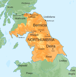
Le Gododdin [ɡoˈdoðin] était un des royaumes bretons du nord de l'île de Bretagne (Hen Ogledd & Northumbrie), au nord du mur d'Hadrien et, partiellement, au sud du mur d'Antonin, qui s'était constitué après le départ des troupes romaines.

1. Histoire

Y Gododdin est un récit du barde Aneurin sur une défaite du Manaw Gododdin, royaume dépendant du précédent, dont la capitale était Caer Eiddyn (Édimbourg), devant les envahisseurs saxons de Bernicie et de Deira, autour de Catterick (Yorkshire), vers l'an 600. C'est sans doute le texte le plus ancien de la littérature galloise. La plus ancienne version du manuscrit date du XIIIe siècle.

1. Liste des rois

après 470 Cynvelyn mab Arthwys mab Mar. Cynwyd Cynwydion son fils ; Cynfelyn Drwsgl, son fils ; Clydno Eidyn, son frère. ? Mynyddog Mwynfawr

1. Articles connexes

Votadini Cambrien (langue) Y Gododdin (poème)

1. Bibliographie

(en) Tim Clarkson, The Men of the North. The Britons of southern Scotland, Edinburgh, John Donald, 2010 (ISBN 9781906566180), p. 230.

1. Lien externe

(en) e-text de Y Gododdin par le Projet Gutenberg

Portail du monde celtique Portail du haut Moyen Âge

Nearby Places View Menu
Location Image
0 m

Northumbria

Northumbria was an early medieval English kingdom, existing between 654 and 1066 AD, spanning modern-day Northern England and Southern Scotland. The name derives from the Old English Norþhymbre meaning "the people or province north of the Humber", as opposed to the people south of the Humber Estuary. What was to become Northumbria started as two kingdoms, Deira in the south and Bernicia in the north. Conflict in the first half of the seventh century ended with the murder of the last king of Deira in 651, and Northumbria was thereafter unified under Bernician kings. At its height, the kingdom extended from the Humber, Peak District and the River Mersey on the south to the Firth of Forth on the north. Northumbria ceased to be an independent kingdom in the mid-tenth century when Deira was conquered by the Danes and formed into the Kingdom of York. The rump Earldom of Bamburgh maintained control of Bernicia for a period of time; however, the area north of the Tweed was eventually absorbed into the medieval Kingdom of Scotland while the portion south of the Tweed was absorbed into the Kingdom of England as the county of Northumberland and County Palatine of Durham.
771 m

Allolee to Walltown

Allolee to Walltown is the name given to a Site of Special Scientific Interest (SSSI) in Northumberland, England. The site, which follows the path of a section of Hadrian's Wall, is notable for an unusually wide range of grassland types growing on thin soil above the Whin Sill, a rock formation peculiar to the Northern Pennines.
Location Image
886 m

Milecastle 44

Milecastle 44 (Allolee) was a milecastle on Hadrian's Wall (grid reference NY68886694).
Location Image
900 m

Milecastle 45

Milecastle 45 (Walltown) was a milecastle on Hadrian's Wall (grid reference NY67716657).
1.0 km

Alloa Lea Quarry Cave

Alloa Lea Quarry Cave is a short cave in the Five Yard Limestone of the Alston Block in Northumberland, England. It is situated in an old quarry on the road between Alloa Lea and Walltown. The total length of the cave is 10m.