


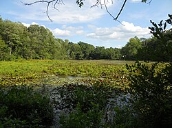
Maudslay State Park is a landscaped and decorative public recreation area located along the right bank of the Merrimack River in Newburyport, Massachusetts, in the United States. The park is bordered on the west side by the Artichoke River, which is also the border between Newburyport and West Newbury. It features thickets and gardens, rolling meadows, tall pines, and one of the largest naturally occurring stands of mountain laurel in the Commonwealth.
Gallery


Sponsored
Location
2 explorers visited this place
1.1 km
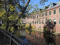
The Artichoke Riverlong), is a tributary of the Merrimack River in Massachusetts in the United States. It is in Essex County, Massachusetts, and flows generally north, marking the boundary between West Newbury and Newburyport. The Upper and Lower Artichoke reservoirs are impoundments of the river that acts as a water source for nearby towns.
Despite the short length of the river, there are three dams along its course, the Emory Lane Dam, the Lower Artichoke Dam and the Upper Artichoke Dam.
The river is named for the Jerusalem Artichoke, which had been harvested nearby by Native Americans and early settlers.

2.0 km
The Chain Bridge in Newburyport, Massachusetts, is a "look-alike" replica built in 1910 to replace the "first suspension bridge" constructed in the United States in 1810. Since the current structure is one of a series of bridges at this location since 1793, it is "the oldest continually occupied, long span, bridge crossing" in the US. It has also been called the Essex-Merrimac Bridge or Newburyport Chain Bridge.
It is a 225-foot chain bridge, a single-span suspension bridge, which crosses the right branch of the Merrimack River as it flows around Deer Island. The boundary between the cities of Newburyport and Amesbury, Massachusetts, runs through Deer Island, so Chain Bridge connects the two communities. Crossing from the island to the left bank of the Merrimack requires traversing the Derek S. Hines Memorial Bridge, formerly the Essex-Merrimack Drawbridge, which was reconstructed and reopened in August 2012. As the Chain Bridge is better known because of its structure, it is sometimes incorrectly identified as a single bridge spanning the Merrimack.
2.1 km
Fort Nichols was a fort that existed in 1775 in Amesbury, Massachusetts during the American Revolutionary War. It was also known as Fort Merrimac during its existence. Two possible locations for the fort exist. One is a location named Salisbury Point on modern topographic maps, where Interstate 95 crosses the Merrimack River; this is the location of the coordinates given. Another possibility is the mouth of the Merrimack at Salisbury Beach in Salisbury. One source states that the American Civil War Fort at Salisbury Point was built at the same location as Fort Nichols, which is given as "at Salisbury Point, opposite Newburyport". The Civil War fort was sometimes referred to as Fort Nichols by local civilians.

2.1 km
Deer Island is a small island with only 1-2 residences, located in the Merrimack River in Amesbury, Massachusetts. The island connects to mainland Amesbury by way of the Derek S. Hines Memorial Bridge, and to neighboring Newburyport via Chain Bridge.
2.2 km
The Powwow River is a 22.8-mile-long river located in New Hampshire and Massachusetts in the United States. It is a tributary of the Merrimack River, part of the Gulf of Maine watershed.
Within the park, visitors can find numerous ornamental trees, such as azaleas, and rhododendrons. The park is managed by the Department of Conservation and Recreation.