Location Image

Kilpatrick Hills

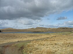
The Kilpatrick Hills are a range of hills in central Scotland, stretching from Dumbarton in the west to Strathblane in the east. Strathblane divides the Kilpatricks from the Campsie Fells to the east, while to the north is part of the Loch Lomond and the Trossachs National Park. To west and south the hills are fringed by the settlements of Balloch, Dumbarton, Milton, Bowling, Old Kilpatrick, Clydebank, Bearsden and Milngavie. The majority of the range is within West Dunbartonshire, although it extends into the East Dunbartonshire and Stirling areas. The highest points in the range are Duncolm (1,314 ft or 401 m) and Fynloch (1,313 ft or 400 m). The Kilpatricks offer a number of viewpoints and places of interest: among the best known are Doughnot Hill and The Whangie. The area features several reservoirs. The hills are of volcanic origin, modified by subsequent glaciation.

Nearby Places View Menu
1.1 km

Duncolm

Duncolm (Scottish Gaelic: Dùn Choluim) is a hill in Scotland. It is the highest point in both West Dunbartonshire and the Kilpatrick Hills, at an elevation of 401 metres (1,316 ft). Its name means "Fort of Columba". It lies near Loch Humphrey. There is an easy path to the summit from the south-west, which passes over two subsidiary peaks, Little Duncolm and Middle Duncolm.
Location Image
2.2 km

Clydebank (district)

Clydebank (Scottish Gaelic: Bruach Chluaidh) was, from 1975 to 1996, one of nineteen local government districts in the Strathclyde region of Scotland, covering the town of Clydebank and adjoining areas to the north-west of the city of Glasgow.
Location Image
2.9 km

Loch Humphrey

Loch Humphrey is a loch in West Dunbartonshire, Scotland. It is fished for mainly perch and occasional trout by members of the Bearsden Angling Club, who have a boat and a boatshed at the loch. It is in the Kilpatrick Hills, and is close to Duncolm. It can be reached by a cart track from Old Kilpatrick; the terrain is not difficult going but it is quite a steep climb.
Location Image
4.3 km

Cochno Stone

The Cochno Stone is a large cup and ring marked rock at Auchnacraig, Faifley, West Dunbartonshire, Scotland, next to the Cochno farm. It is also known variously as "Whitehill 1" and "the Druid Stone". The Bronze Age rock art is found on a stone measuring 42 by 26 feet (12.8 by 7.9 metres), and was documented in 1887 by the Rev. James Harvey. It features around 90 carved indentations, considered to be one of the finest sets of petroglyphs in Scotland. The stone was reburied in 1965 to protect it against vandalism. In 2015 it was partially re-exposed for investigation during a three-day dig by a team involving archaeologists from the University of Glasgow, with a more complete re-exposure following a year later.