
 English
 Français
Loch Humphrey
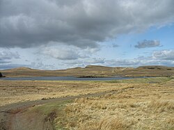
Loch Humphrey is a loch in West Dunbartonshire, Scotland. It is fished for mainly perch and occasional trout by members of the Bearsden Angling Club, who have a boat and a boatshed at the loch. It is in the Kilpatrick Hills, and is close to Duncolm. It can be reached by a cart track from Old Kilpatrick; the terrain is not difficult going but it is quite a steep climb.
Nearby Places View Menu
1.9 km
Duncolm
Duncolm (Scottish Gaelic: Dùn Choluim) is a hill in Scotland. It is the highest point in both West Dunbartonshire and the Kilpatrick Hills, at an elevation of 401 metres (1,316 ft). Its name means "Fort of Columba".
It lies near Loch Humphrey. There is an easy path to the summit from the south-west, which passes over two subsidiary peaks, Little Duncolm and Middle Duncolm.

2.5 km
Bowling railway station (Lanarkshire and Dunbartonshire Railway)
Bowling railway station was a railway station located in the village of Bowling, Scotland, on the Lanarkshire and Dunbartonshire Railway.
Bowling station was closed in 1951 before this section of the L&DR was abandoned in 1960 (the parallel GH&DR being retained and electrified as part of the North Clyde electrification scheme). The trackbed through Bowling now forms a footpath and cycleway, part of National Cycle Network Route 7.

2.6 km
Forth and Clyde Canal
The Forth and Clyde Canal is a canal opened in 1790, crossing central Scotland; it provided a route for the seagoing vessels of the day between the Firth of Forth and the Firth of Clyde at the narrowest part of the Scottish Lowlands. This allowed navigation from Edinburgh on the east coast to the port of Glasgow on the west coast. The canal is 35 miles (56 km) long and it runs from the River Carron at Grangemouth to the River Clyde at Bowling, and had an important basin at Port Dundas in Glasgow.
Successful in its day, it suffered as the seagoing vessels were built larger and could no longer pass through. The railway age further impaired the success of the canal, and in the 1930s decline had ended in dormancy. The final decision to close the canal in the early 1960s was made due to maintenance costs of bridges crossing the canal exceeding the revenues it brought in. However, subsidies to the rail network were also a cause for its decline and the closure ended the movement of the east-coast Forth River fishing fleets across the country to fish the Irish Sea. The lack of political and financial foresight also removed a historical recreational waterway and potential future revenue generator to the town of Grangemouth. Unlike the majority of major canals the route through Grangemouth was drained and backfilled before 1967 to create a new carriageway for port traffic.
The M8 motorway in the eastern approaches to Glasgow took over some of the alignment of the canal, but more recent ideas have regenerated the utility of the canal for leisure use.

2.6 km
Bowling, West Dunbartonshire
Bowling (Scots: Bowlin, Scottish Gaelic: Bolan) is a village in West Dunbartonshire, Scotland, with a population of 740 (2015).
It lies on the north bank of the Firth of Clyde, between the towns of Clydebank and Dumbarton. It is 1+1⁄2 miles (2.5 kilometres) west of Old Kilpatrick which is at one end of the Antonine Wall and therefore represents the extreme limit of the Roman Empire on the west coast of the island of Great Britain.