
 English
 Français
Sparrowpit
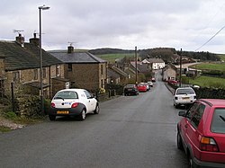
Sparrowpit is a small village between Chapel-en-le-Frith and Peak Forest in the High Peak area of the Peak District, Derbyshire, England. The name is derived from 'spar row pit' from the fluorspar mines. The village has an active community, including a methodist chapel and village hall. It is situated at a crossroads where the main road (A623) takes a right-angled bend at the Wanted Inn. From this junction, one minor road takes a different and hillier route to Chapel-en-le-Frith, and another heads for Mam Tor and Castleton by way of the Winnats Pass. The watershed between rivers running east into the North Sea and west into the Irish Sea runs almost exactly through the village.
Nearby Places View Menu

1.1 km
Gautries Rake
Gautries Rake in Sparrowpit, Derbyshire, east of Chapel-en-le-Frith is a preserved example of a linear sequence of lead mine workings that date back to at least the late 17th century.
The remains were classified as a scheduled monument on 21 March 2013.

1.3 km
Bagshaw
Bagshaw is a hamlet in Derbyshire, England. The hamlet falls within the civil parish of Chapel-en-le-Frith.
It is about 1.2 km or 0.75 miles east of Chapel-en-le-Frith, and within the boundaries of the Peak District National Park. It is in the valley of a small stream which flows westward towards the Black Brook. It has a small Methodist chapel.

1.9 km
Rushop
Rushop or Rushup is a hamlet in Derbyshire, in the parish of Chapel-en-le-Frith. The main cluster of buildings lies on Rushup Lane, which connects the hamlet of Perryfoot to the south and the former A625 road, now unclassified, below Rushup Edge to the north.
There is archaeological and documentary evidence that there was a settlement at this site since before the Roman invasion of Britain. The settlement is alleged to have been a British village, under nominal Anglo Saxon rule after the fall of the area to Angles from Bernicia around 590, mainly due to the lack of Anglo Saxon placenames in the valley and the presence of names, such as Eccles, Inch and Pen-, which have origins in a Brythonic language of Britain.
Rushup Hall was built in the early 19th century and was designated as a Grade II listed building in 1984. The former turnpike road running from east to west north of the hamlet towards Chapel-en-le-Frith was part of the A625 (now A6187) until landslips at Mam Tor led to the closure of the main road in 1979, and the declassification of this section; a 19th-century milestone near the junction with Rushup Lane is also Grade II listed.
The Pennine Bridleway follows Rushup Lane.

2.0 km
Slackhall
Slackhall is a hamlet in Derbyshire, England. The hamlet falls within the civil parish of Chapel-en-le-Frith.
It is about 1.2 km (or 0.75 miles) east of Chapel-en-le-Frith and within the boundaries of the Peak District National Park.
The hamlet contains a number of listed buildings, including Ford Hall. Slack Hall itself lies to the south of the hamlet, near Bagshaw.