
 English
 Français

Aldbrough (Yorkshire de l'Est)
Aldbrough est une paroisse civile et un village du Yorkshire de l'Est, en Angleterre.
1. Notes et références
(en) Cet article est partiellement ou en totalité issu de l’article de Wikipédia en anglais intitulé « Aldbrough, East Riding of Yorkshire » (voir la liste des auteurs).
1. Liens externes
(en) Site officiel Ressource relative à la géographie : Open Domesday
Portail du Yorkshire
Lieux à Proximité Voir Menu

0 m
Aldbrough, East Riding of Yorkshire
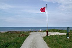
Aldbrough is a village and civil parish in the East Riding of Yorkshire, England, about 12 miles (19 km) north-east of Hull at the junction of the B1242 and B1238 roads. It lies near to the North Sea coast within the area of Holderness.
From the mediaeval era until the 19th century Aldbrough was part of Holderness Wapentake.
Between 1894 and 1935 it was part of the Skirlaugh Rural District and from 1935 to 1974 part of the Holderness Rural District, in the East Riding of Yorkshire. Between 1974 and 1996 it was part of the Borough of Holderness, in the county of Humberside.
The name Aldbrough derives from the Old English aldburh meaning 'old burh' (fortification).

1.7 km
Etherdwick
Etherdwick is a hamlet in the East Riding of Yorkshire, England in an area known as Holderness.
It is approximately 9 miles (14 km) north-west of Withernsea town centre. It lies 1.5 miles (2.4 km) to the west of the B1242 road.
The hamlet forms part of the civil parish of Aldbrough.
In 1823 Bulmer's Topography, History and Directory of East Yorkshire wrote Etherdwick's name as "Etherdwicke". At the time it was in the Wapentake and Liberty of Holderness. Recorded in the hamlet were three farmers.
2.1 km
RAF Cowden
RAF Cowden was a Royal Air Force bombing range, near to the village of Aldbrough, East Riding of Yorkshire, England. The site was used by the RAF and other air forces between 1959 and 1998, though the land part of the site was used by the army for training in the Second World War. Since closure, explosive ordnance disposal (EOD) teams have had to visit the site on numerous occasions due to erosion of the cliffs by the North Sea revealing old practise bombs.

2.4 km
Tansterne
Tansterne is a hamlet in the East Riding of Yorkshire, England. It is situated approximately 2.5 miles (4 km) north-east of Sproatley and 1 mile (1.6 km) south-west of Aldbrough. It lies off the B1238 road.
It forms part of the civil parish of Aldbrough.

2.4 km
East Newton
East Newton is a hamlet in the civil parish of Aldbrough, in the East Riding of Yorkshire, England, in an area known as Holderness. It is situated approximately 8 miles (13 km) north-west of Withernsea town centre. It lies to the east of the B1242 road on the North Sea coast.
East Newton was formerly a township in the parish of Aldbrough, in 1866 East Newton became a civil parish, on 1 April 1935 the parish was abolished and merged with Aldbrough. In 1931 the parish had a population of 25.