
 English
 Français

Heath Charnock
Heath Charnock est un village et une paroisse civile du Lancashire, en Angleterre.
1. Notes et références


1. Liens externes
Portail de l’Angleterre
Nearby Places View Menu
74 m
Heath Charnock
Heath Charnock is a small village and civil parish of the Borough of Chorley in Lancashire, England. According to the United Kingdom Census 2001 it has a population of 2,065, reducing to 2,026 at the 2011 Census.
466 m
Rawlinson Bridge railway station
Rawlinson Bridge was the first railway station in the Borough of Chorley in Lancashire, England. The station was located in the village of Heath Charnock and was situated on the Bolton to Preston Railway. The station opened on 4 February 1841 by act of Parliament, the Bolton and Preston Railway Company had constructed a link with the Manchester line comprising nine and a half miles of railway to a station which was to be a temporary terminus as the railway continued to be built towards Chorley. Four years later on 22 December 1841 the line had reached Chorley and was superseded by more centralised stations at Chorley and Adlington.
No traces of the former terminus remain although after closure the site became home of the junction linking the mineral railway which served Ellerbeck Colliery to the main line. This line and the colliery closed in the 1960s.
857 m
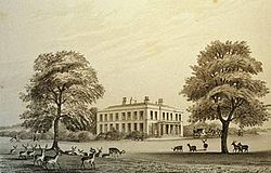
Duxbury Hall
Duxbury Hall was a 19th-century country house in Duxbury Park estate in Duxbury Woods, Duxbury, Lancashire that has been demolished.
The hall was a plain two-storey building faced in millstone grit ashlar standing in a well-wooded park 1½ miles (2.5 km) south of Chorley. The entrance on the east front was via a Doric portico. In the cellars was evidence of an earlier building, probably a brick-built house enclosing a courtyard on three sides. The later building followed the same plan, having north and south wings extending westward from the east front. The roof was made of green slate.

1.1 km
Duxbury Woods
Duxbury Woods is an area of woodland and parkland situated in Chorley, Lancashire, at the foot of the West Pennine Moors. The area originally existed as a township with the council meeting at the Yarrow Bridge pub; this was absorbed into Chorley Rural District in the early 20th century.
Duxbury today is home to Duxbury Jubilee Park, Duxbury Golf Course, the woods and the River Yarrow. It was also home to Duxbury Hall, the seat of the Standish family. The estate and grounds still exist with the gardens, stables, coachhouse, 16th century barn and Lodges on Bolton Road and Wigan Lane remaining. The Hall itself was built in the 17th century, and was demolished to make way for housing in 1957. Many consider the great barn (which remains) to be the original home of the pilgrim father Myles Standish.
Duxbury, Massachusetts was named after this area.

1.3 km
Ellerbeck Colliery
Ellerbeck Colliery was a coal mine located on the border of Coppull and Adlington in the Borough of Chorley in Lancashire, England. The Hilton House and Red Moss Coal Company sank the first shaft in 1876 and the colliery closed in 1928.
In 1896 Ellerbeck employed 460 underground workers and 148 on the surface. In 1923 Ellerbeck Nos. 1 & 2 pits had expanded to employ 892 underground workers and 156 on the surface. Ten years later the colliery was owned by the Blackrod Colliery Company and the pit employed 50 underground and 22 surface workers mining the Bone, Wigan Six Feet and New coal seams. The colliery was nationalised in 1947 becoming part of the National Coal Board and was redeveloped employing 411 men in 1958 before finally closing in 1965.
The colliery was served by a branch line of the Lancashire Union Railway, remnants of which including the old bridge foundations on the Leeds-Liverpool Canal are evident today. The branch line was shared with neighbouring Duxbury Park Colliery. The colliery was so important to the Lancashire & Yorkshire Railway that, despite not being a passenger station, it appeared on their route maps,