
 English
 Français

West Cairn Hill
West Cairn Hill is a hill in the Pentland Hills range of Scotland. With a height of 562 m (1,844 ft), it is the fifth highest elevation and lies on the western flank of the approximately 20 mi (32 km) long chain of hills. The border between the council areas of the Scottish Borders and West Lothian runs over the knoll. The closest settlement is the hamlet of Carlops around six kilometers to the southeast. West Calder is nine kilometers to the northwest and Penicuik is eleven kilometers to the east. The Cauldstane Slap pass runs at the saddle point between West and East Cairn Hill. The surrounding hills include Colzium Hill and Torweaving Hill in the southwest, East Cairn Hill in the northeast, and Wether Law in the east.
Lieux à Proximité Voir Menu
7.8 km
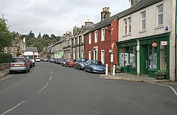
West Linton
West Linton (en gaélique écossais : Liontan Ruairidh) est un village situé dans la lieutenance de Tweeddale, en Écosse, à 26 km au sud-ouest d'Édimbourg.
Le festival The Whipman a lieu dans le village depuis 1803. Il commence la veille du premier samedi de juin et dure huit jours, période pendant laquelle se tiennent de nombreuses festivités et activités sportives.
8.6 km

8.8 km
Scald Law
Scald Law est un sommet du Midlothian, en Écosse. Avec ses 579 mètres d'altitude, c'est le point culminant des Pentland Hills. Il est composé de roches volcaniques du Dévonien.

9.7 km

9.8 km
East Calder
East Calder est un village situé dans le West Lothian, en Écosse. En 2020 la population d'East Calder est estimée à 6 430 habitants.