
 English
 Français

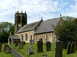
Newbald is a civil parish in the East Riding of Yorkshire, England. It is situated approximately 8 miles (13 km) west of the market town of Beverley and covering an area of 2,429.702 hectares (6,003.92 acres). The civil parish is formed by the village of North Newbald and the hamlet of South Newbald. It is drained by Ings Beck which ultimately feeds into the Humber at Brough, East Riding of Yorkshire. The beck powered a watermill to the south of the village. East of the village, the South Cave to Market Weighton or Goodmanham section of the Yorkshire Wolds Way passes through Swin Dale. According to the 2011 UK census, Newbald parish had a population of 1,115, an increase on the 2001 UK census figure of 989.
Lieux à Proximité Voir Menu

0 m
Newbald
Newbald est une paroisse civile du Yorkshire de l'Est, en Angleterre.

2.9 km
Hotham (Yorkshire de l'Est)
Hotham est une paroisse civile et un village du Yorkshire de l'Est, en Angleterre.
3.0 km
Sancton
Sancton est un village et une paroisse civile du Yorkshire de l'Est, en Angleterre. Il est situé sur la route A1034, à trois kilomètres environ au sud-est de la ville de Market Weighton. Au moment du recensement de 2011, il comptait 286 habitants.

3.7 km
South Cliffe
South Cliffe est une paroisse civile et un village du Yorkshire de l'Est, en Angleterre.

4.3 km
North Cave
North Cave est un village et une paroisse civile du Yorkshire de l'Est, en Angleterre.