Location Image

Mayfield, Midlothian

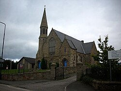
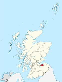
Mayfield is a community in Midlothian, Scotland, located just south of Dalkeith near Edinburgh between the A68 and the A7 south. It had an estimated population of 13,690 in 2020. This housing development was built in the 1950s as overspill accommodation for the colliery workers of nearby Newtongrange and Easthouses and for other essential workers, as well as to house the workforce for a small but relatively successful industrial estate. The decline of the coal industry in the 1980s led to the closure of the collieries. The massive growth in population in this part of Newbattle parish in the 1950s led to the existing mining village of Easthouses being virtually 'swallowed up' into the new housing development of Mayfield, which today has a population similar to that of a small town. With the communities of Mayfield and Easthouses ever expanding, in 1955 the Church of Scotland had an additional church building erected within Newbattle parish. Mayfield and Easthouses church was built in a more utilitarian and functional style than the 18th-century building at Newbattle, as it had to double as both a place of worship and a place where the various church and other organisations (e.g. Boys Brigade [Anchor Boys, Junior Section, and Company Section], Girls Brigade, Cubs, Scouts, and Brownies) could establish themselves. There are three primary schools: Mayfield Primary School which is conjoined with St. Luke's RC Primary School, and Lawfield Primary School (a new school made up of the former Langlaw Primary and Bryans Primary).

Lieux à Proximité Voir Menu
Location Image
1.9 km

Newtongrange

Newtongrange est un ancien village minier dans le Midlothian, en Écosse.
Location Image
3.1 km

Château de Dalhousie

Le château de Dalhousie est un château fort des XIIIe et XVIIe siècles situé à Bonnyrigg dans le Midlothian à 13 km au sud d’Édimbourg en Écosse. Il sert d'hôtel et de restaurant de luxe depuis 1972.
Location Image
3.2 km

Gorebridge

Gorebridge est un ancien village minier dans le Midlothian, en Écosse.
Location Image
3.3 km

Midlothian (Écosse)

Le Midlothian (Meadhan Lodainn en écossais) est une des 32 council areas et une région de lieutenance de l’Écosse. Le Midlothian est frontalier avec les Scottish Borders, l’East Lothian et la ville d’Édimbourg. C’était auparavant un comté entre le West Lothian à l’ouest, le Lanarkshire et le Peeblesshire au sud, le Berwickshire et l’East Lothian à l’est. Il comprenait alors la ville d’Édimbourg et était parfois appelé Edinburghshire. De 1708 à 1918, le comté fut une circonscription électorale qui devint célèbre lors de la campagne pour les législatives de 1880. Le candidat libéral (et futur Premier ministre) William Ewart Gladstone s'y présentait. Il fit toute une série de discours marquants sur la politique étrangère. La campagne électorale fut dès lors surnommée « campagne du Midlothian ».
Location Image
3.4 km

Dalkeith

Dalkeith est une ville écossaise, capitale administrative du council area et de la région de lieutenance du Midlothian, située sur la rivière North Esk. De 1975 à 1996, elle était la capitale administrative du district du Midlothian, au sein de la région du Lothian. La ville est divisée en 4 secteurs distincts : Dalkeith, proprement dit avec son centre-ville et son noyau historique, Eskbank à l'ouest, Woodburn à l'est. Eskbank est le quartier le plus cossu avec ses grandes maisons victoriennes. Au sud de Eskbank, se trouve Newbattle avec son abbaye. Depuis environ 1935, Woodburn est devenue un quartier peuplé de gens actifs. Dalkeith est le principal centre administratif du Midlothian. À Thornyhall, près de Dalkeith et tout près de la zone industrielle, a été récemment bâti le campus de Dalkeith, avec ses collèges et Saint-David.