
 English
 Français

New Mills
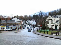
New Mills is a town in the Borough of High Peak, Derbyshire, England, 8 miles (13 km) south-east of Stockport and 13 miles (21 km) from Manchester at the confluence of the River Goyt and Sett. It is close to the border with Cheshire and above the Torrs, a 70 feet (21 m) deep gorge cut through carboniferous sandstone, on the north-western edge of the Peak District National Park. New Mills has a population of approximately 12,000, in a civil parish which includes the villages and hamlets of Whitle, Thornsett, Hague Bar, Rowarth, Brookbottom, Gowhole and Birch Vale. New Mills was first noted for coal mining, then for cotton spinning, bleaching and calico printing. It was served by the Peak Forest Canal, three railway lines and the A6 trunk road. Redundant mills were bought up in the mid-twentieth century by sweet manufacturer Swizzels Matlow. New Mills was a stronghold of Methodism. New Mills is twinned with Alsfeld, Germany, and a road is named in honour of its twin town called Alsfeld Way.
Lieux à Proximité Voir Menu


Buxworth

Whaley Bridge
