


The Chapeauroux (French pronunciation: [ʃapoʁu]) is a 56.1-kilometre (34.9 mi) long river in the Lozère and Haute-Loire départements, south-central France. Its source is near Estables, in the Margeride. It flows generally northeast. It is a left tributary of the Allier into which it flows between Saint-Bonnet-de-Montauroux and Saint-Christophe-d'Allier.
Localisation
1 explorateur a visité ce lieu
35 m
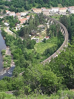
Le viaduc de Chapeauroux, ou viaduc du Nouveau-Monde, est un pont ferroviaire en pierre qui enjambe la rivière du Chapeauroux sur la commune de Saint-Bonnet-de-Montauroux en Lozère. Le pont, achevé en 1870, appartient à la ligne des Cévennes.

288 m
Condate est une station routière mentionnée sur la table de Peutinger sur l'itinéraire de Revessio à Anderitum.
Le site, dont le nom indique la présence d'un confluent, est très certainement situé au nord du territoire communal de Saint-Bonnet-de-Montauroux, au confluent de l'Allier et du Chapeauroux, à l'extrême nord-est du département français de la Lozère. Le site se développe également sur la commune de Saint-Haon, sur la rive droite de l'Allier.

390 m
Les gorges de l'Allier se présentent comme un canyon creusé par la rivière Allier. C'est un site naturel devenu touristique, surtout depuis la mise en place du train touristique qui longe les gorges entre les départements de la Haute-Loire et de la Lozère.

555 m
La gare de Chapeauroux est une gare ferroviaire française de la ligne de Saint-Germain-des-Fossés à Nîmes-Courbessac, située au lieu-dit Chapeauroux sur le territoire de la commune de Saint Bonnet-Laval, dans le département de la Lozère en région Occitanie.
C'est une gare de la Société nationale des chemins de fer français desservie par les trains TER Occitanie et TER Auvergne-Rhône-Alpes.
Elle se situe à proximité du Nouveau Monde, hameau de Saint-Haon.

1.9 km
L'église Saint-Haon est une église catholique située à Saint-Haon, en France.
