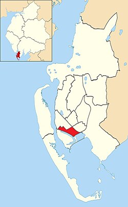
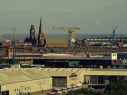
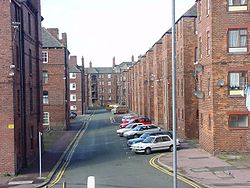
Central Barrow refers both to the town centre of Barrow-in-Furness, Cumbria, England and to the Town Council electoral ward that roughly covers the eastern part of that town centre. In 2001 5,584 (ranking 5th out of 13) lived in the Central ward. The population density was 55.96 per hectare, which was well above the local average of 9.24, and England average, 3.77. The population of Central ward had reduced to 4,583 at the 2011 Census. Central Barrow is amongst the 3% most deprived areas in the country and households have an average weekly income around £100 lower than the region's average, however the area being the central business district of the town is also home to many of Barrow's retail outlets, as well as a large amount of offices, restaurants and governmental buildings. Part of the £200 million Waterfront Barrow-in-Furness project is being constructed in the southern part of Central Barrow (including the new Marina Village). Whilst still an electoral ward for Barrow Town Council, the ward was combined at a district/ local authority level with Barrow Island and Hindpool wards in April 2023 following formation of the new Westmorland and Furness Local Authority and be named 'Old Barrow'. In a bid to tackle issues related with Central Barrow such as deprivation, unemployment and poor housing quality/choice, Barrow Borough Council is currently preparing the 'Central Barrow Masterplan' which will set out guidelines for the redevelopment of Central Barrow. The plan will also put forward proposals for a bus station/transport interchange to replace the existing shelters outside of the town hall. It is not yet known when the plan will be published or what exactly it will include.

Lieux à Proximité Voir Menu
Location Image
407 m

Barrow-in-Furness

Barrow-in-Furness est une ville portuaire et industrielle de Cumbria, située dans le nord-ouest de l'Angleterre au Royaume-Uni. En 2011, Barrow-in-Furness avait une population de 55 489 habitants.
Location Image
490 m

Barrow-in-Furness (district)

Barrow-in-Furness était un district non métropolitain de Cumbria, en Angleterre. Il avait le statut de borough. Barrow-in-Furness a été intégrée dans une nouvelle entité administrative. Aujourd'hui, maintenat cette zone fait partie du district unitaire de Westmorland and Furness, résultant d'une réorganisation territoriale visant à améliorer la gestion locale. Il portait le nom de sa principale ville, Barrow-in-Furness. Les autres principales villes du district sont Dalton-in-Furness, Roose et Askam-in-Furness. C'est le plus petit district du comté, et le plus densément peuplé. Le district etait créé le 1er avril 1974. Il etait issu de la fusion de l'ancien borough de Barrow-in-Furness et du district urbain de Dalton-in-Furness.
Location Image
1.1 km

Barrow (île)

L'île Barrow est une ancienne île de la ville de Barrow-in-Furness, dans le comté de Cumbria en Angleterre. Originellement séparée de la Grande-Bretagne, elle a été reliée au continent en 1860. Elle est séparée de l'île de Walney par le détroit de Walney.
Location Image
1.6 km

Pont de Walney

Le pont de Walney (en anglais : Walney Bridge), officiellement nommé Jubilee Bridge, est un pont basculant situé à Barrow-in-Furness, Cumbria, en Angleterre. Achevé en 1908, il enjambe le chenal Walney, et relie l’île Barrow à l’île Walney. La route nationale A590, qui a son terminus ouest sur Walney, passe sur le pont.
Location Image
1.6 km

Chenal Walney

Le chenal Walney (en anglais : Walney Channel) sépare l’île Walney du continent britannique. La partie nord du chenal s’ouvre sur l’estuaire du Duddon. Elle est à la fois la plus étroite et la moins profonde. La moitié sud du chenal est plus large, et elle est régulièrement draguée pour permettre aux navires d’accéder au port de Barrow-in-Furness. Cette moitié s’ouvre sur la baie de Morecambe. Le chenal est enjambé par le pont de Walney (officiellement Jubilee Bridge) achevé en 1908. En raison des besoins de la navigation, en particulier des activités du chantier naval Vickers, il a été construit comme un pont basculant.