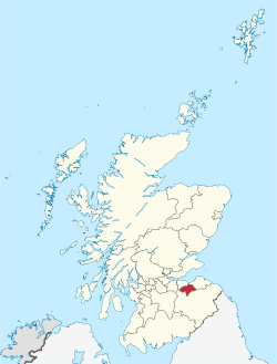
Elginhaugh Roman Fort was a Roman fort of the 1st century AD, located in Midlothian, Scotland. Elginhaugh is the most completely excavated timber-built auxiliary fort in the Roman Empire. The site of the Flavian (1st century) fort lies 1 km to the west of the modern town of Dalkeith, south-east of Edinburgh. The fort, discovered in 1979 by aerial reconnaissance, takes its name from the nearby hamlet of Elginhaugh. It was fully excavated, along with much of its large annexe, during 1986-87 by Dr William Hanson. The excavation confirmed the broad consistency of auxiliary fort plans (in terms of general layout and the identification of specific building types), but highlighted their individual uniqueness in relation to plan detail. Of particular importance, in relation to the traditional interpretation of fort plans, is the recognition that it was the norm to house horses and men together in stable-barracks, whose number and disposition indicate that the fort cannot have housed any single standard unit, and was probably occupied by a vexillation of cavalry. Extensive examination of the annexe highlights the ancillary, probably military, character of the activities taking place there and emphasises, in contrast with the fort, substantive changes in use over a relatively short time-span.

Lieux à Proximité Voir Menu
Location Image
1.1 km

Midlothian (Écosse)

Le Midlothian (Meadhan Lodainn en écossais) est une des 32 council areas et une région de lieutenance de l’Écosse. Le Midlothian est frontalier avec les Scottish Borders, l’East Lothian et la ville d’Édimbourg. C’était auparavant un comté entre le West Lothian à l’ouest, le Lanarkshire et le Peeblesshire au sud, le Berwickshire et l’East Lothian à l’est. Il comprenait alors la ville d’Édimbourg et était parfois appelé Edinburghshire. De 1708 à 1918, le comté fut une circonscription électorale qui devint célèbre lors de la campagne pour les législatives de 1880. Le candidat libéral (et futur Premier ministre) William Ewart Gladstone s'y présentait. Il fit toute une série de discours marquants sur la politique étrangère. La campagne électorale fut dès lors surnommée « campagne du Midlothian ».
Location Image
1.2 km

Dalkeith

Dalkeith est une ville écossaise, capitale administrative du council area et de la région de lieutenance du Midlothian, située sur la rivière North Esk. De 1975 à 1996, elle était la capitale administrative du district du Midlothian, au sein de la région du Lothian. La ville est divisée en 4 secteurs distincts : Dalkeith, proprement dit avec son centre-ville et son noyau historique, Eskbank à l'ouest, Woodburn à l'est. Eskbank est le quartier le plus cossu avec ses grandes maisons victoriennes. Au sud de Eskbank, se trouve Newbattle avec son abbaye. Depuis environ 1935, Woodburn est devenue un quartier peuplé de gens actifs. Dalkeith est le principal centre administratif du Midlothian. À Thornyhall, près de Dalkeith et tout près de la zone industrielle, a été récemment bâti le campus de Dalkeith, avec ses collèges et Saint-David.
Location Image
1.6 km

Lothian

Le Lothian (Lowden en Scots, Lodainn en écossais, anciennement francisé en Lothien ou Lothiane) est une région traditionnelle d'Écosse, s'étendant entre la rive sud du Firth of Forth et les Lammermuir Hills (en). Selon une légende populaire, son nom proviendrait du semi-légendaire roi breton Loth ou Lot.
Location Image
2.4 km

Danderhall

Danderhall est un village dans le Midlothian en banlieue d’Édimbourg, en Écosse.
Location Image
2.4 km

Bonnyrigg

Bonnyrigg est une ville du Midlothian en Écosse. La ville comptait 14 663 habitants en 2001 et 15 677 selon le recensement de 2011.