English
 Français

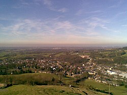
Tegg's Nose is a hill east of Macclesfield in Cheshire, England. It has a short ridge with a high point of 380 metres (1,250 ft) at SJ947725, terminating in a promontory at the southern end. It lies on the western edge of the Peak District, although outside the boundary of the national park. Much of the hill's area falls within the Tegg's Nose Country Park, managed by Cheshire East Council Countryside Management Service; Tegg's Nose is also part of the Environmentally Sensitive Area Scheme. Historically quarried for millstone grit, Tegg's Nose now includes a range of environments including moorland, meadow, farmland, broadleaved woodland and is rich in wildlife. Recreational uses of the area include walking, orienteering, horse riding, fell running, cycling, mountain biking, rock climbing, sledging and fishing.
Lieux à Proximité Voir Menu
Sutton (Cheshire East)

Higher Hurdsfield
Macclesfield

Rainow