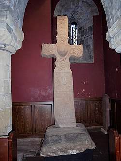
The Dupplin Cross is a carved, monumental Pictish stone, which dates from around 800 AD. It was first recorded by Thomas Pennant in 1769, on a hillside in Strathearn, a little to the north of (and on the opposite bank of the River Earn from) Forteviot and Dunning. In 2002 it was placed in the care of Historic Scotland, and was placed for preservation under the 11th/12th-century tower of St Serf's Church, Dunning. The Dupplin Cross is a high cross, that is a free-standing stone cross. While relatively common in Ireland, Northumbria and in Dál Riata, such crosses are rare survivals in the lands of the Picts, though fragments of shattered crosses (probably cast down during the 16th-century Reformation) show that a number once existed. In the 18th century a second cross, the Cross of Dronachy, was recorded as having stood on the lands of Invermay, south of Forteviot and also overlooking Forteviot, but having fallen and broken. The cross base survives in situ, but the records do not provide details of its exact form. The cross is carved from Old Red Sandstone, and stands about 2.5 metres tall, 1 metre broad over the arms of the cross. It is carved with various scenes, religious, martial and traditional Pictish animal carvings. The cross contains a partially legible inscription, of which only the name CUSTANTIN FILIUS FIRCUS can be read. This name is taken as the Latin form of the early 9th-century Pictish king's Gaelic name Caustantín son of Fergus (fl. 793–820). Since the inscription implies that the cross was carved either during, or shortly after, the reign of Caustantín, it is particularly important as giving a fixed point in the chronology of Pictish sculpture. It also indicates that Gaelic was spoken at the time as it uses the Gaelic personal name of his father in Latin.

Other carved themes on the cross include a rider with an oversized head and ponytail showing him to be a man of authority. On the obverse a man fights bears with his bare hands. The sides include a man (probably David) playing a harp, and hunting dogs.

Lieux à Proximité Voir Menu
Location Image
0 m

Croix de Dupplin

La croix de Dupplin est une haute croix celtique de la province historique du Strathearn, en Écosse, qui a été construite vers 820, pendant ou très peu après le règne de Constantin des Pictes de Fortriú. Cette haute croix est l'une des dernières de la terre des Pictes que l'Écosse conserve.
Location Image
4.4 km

Forteviot

Forteviot (en gaélique écossais: Fothair Tabhaicht) est un village du Strathearn en Écosse sur la rive sud de la rivière Earn, entre Dunning et Perth dans le council area de Perth and Kinross. Le village actuel a été rebâti au cours de la décennie 1920 par John Dewar (en) de la lignée des producteurs de whisky John Dewar & Sons.
5.5 km

Bataille de Dupplin Moor

À la bataille de Dupplin Moor le 11 août 1332, l’armée du prétendant Édouard Balliol et des « déshérités » (en anglais : disinherited), dirigée par Henri de Beaumont, vainc les forces écossaises, pourtant plus nombreuses.
Location Image
6.3 km

Strathearn

Strathearn or Strath Earn (littéralement en gaélique « la large vallée – strath – de la rivière Earn ») est une province historique de l’Écosse centrale qui s’étend du Loch Earn dans l’actuelle région de Perth and Kinross au Firth of Tay. Le Strathearn était le siège d’un des anciens royaumes Pictes traditionnels fondés par un des fils du mythique roi « Cruithne mac Cinge ». Le Starthearn était même considéré jusqu’à l’hypothèse d’Alex Woolf comme le centre de l’ancien royaume de Fortriú que l’on situait au sud du « Mounth » i.e. les Monts Grampians. Jusqu’au milieu du XIVe siècle, le « Mortuath » de Strathearn fut dirigé par les héritiers de l’antique dynastie des Mormaers celtiques locaux qui ne sont toutefois historiquement attestés qu’à partir de 1114. Sous l'influence anglo-normande, le Strathearn devint ensuite un comté qui fut intégré par héritage au domaine royal des Stuarts. Aujourd'hui, le prince William et sa femme Catherine Middleton se voient appelés comte et comtesse de Strathearn quand ils sont en Écosse.
Location Image
7.6 km

Auchterarder

Auchterarder (Uachdar Àrdair en gaélique (gd)) est une ville d'Écosse, situé dans le council area et région de lieutenance du Perth and Kinross. Elle est située au pied des Ochil Hills, dont elle est l'une des portes d'entrée. Elle est célèbre pour abriter sur son territoire l'hôtel Gleneagles, qui accueillit en juillet 2005 le 31e sommet du G8.