
 English
 Français

Preston Patrick
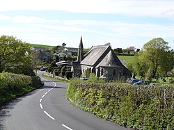
Preston Patrick is a village and civil parish in Westmorland and Furness, Cumbria, England. It has junction 36 of the M6 motorway in its south west corner and extends north east on both sides of the motorway until just beyond the B2564 road. In the 2001 census the parish had a population of 438, decreasing at the 2011 census to 426. It is set in the drumlin landscape south of Kendal. The neighbouring parishes are Old Hutton and Holmescales to the north, Lupton to the east, Beetham to the south and Preston Richard to the west. Preston Patrick has a parish council, the lowest tier of local government in England.
Lieux à Proximité Voir Menu
1 m
Preston Patrick
Preston Patrick est une paroisse civile de Cumbria, située dans le nord-ouest de l'Angleterre.

1.7 km
Preston Richard
Preston Richard est une paroisse civile de Cumbria, dans le nord-ouest de l'Angleterre. Elle comprend le village d'Endmoor, et les hameaux de Crooklands, Birkrigg Park, Milton, Low Park et Summerlands.

2.4 km
Lupton (Cumbria)
Lupton est un village et une paroisse civile de Cumbria, situé dans le nord-ouest de l'Angleterre.

3.2 km
Stainton (Cumbria)
Stainton est un village et une paroisse civile de Cumbria, situé dans le nord-ouest de l'Angleterre.
4.0 km
Old Hutton and Holmescales
Old Hutton and Holmescales est une paroisse civile de Cumbria, située dans le nord-ouest de l'Angleterre.