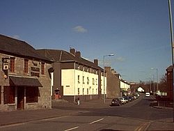
Duntocher (Scottish Gaelic: Dùn Tòchair or Druim Tòchair) is a village in West Dunbartonshire, Scotland. It has an estimated population of 6,850. The etymology of the name of the village indicates that its name means "the fort on the causeway". Duntocher has effectively become a northern suburb of the nearby town of Clydebank, as have neighbouring Hardgate and Faifley. Duntocher expanded due to housebuilding by Clydebank Burgh Council after the Second World War, although the area was never formally absorbed into the burgh. When burghs were abolished by local government reorganisation in 1975, however, Duntocher was included in the larger Clydebank District, which existed until the creation of West Dunbartonshire in 1997. Further housing was built by the Wimpey firm in the late 1960s and early 1970s, on what had been green belt land. Along with Faifley and Hardgate, Duntocher falls within West Dunbartonshire's Kilpatrick ward with a combined population of 12,719 in 2011. At one time this was the most north westerly point on the Glasgow Corporation Transport tram system, trams operating from here via Hardgate to Clydebank, and at times, on to Partick depot. Duntocher historically had several cotton and corn mills, driven by the Duntocher Burn which is the traditional boundary between Duntocher and neighbouring village Hardgate. The Antonine Wall also runs through the village, and ancient Roman fortifications are still visible in the local Goldenhill Park. Lottery funding is to provide funds for a children's playpark at Goldenhill. Sir George Macdonald wrote about the findings at Duntocher. Duntocher has a Roman Catholic church – St. Mary's, a United Free Church of Scotland – Duntocher West, and a Church of Scotland – Duntocher Trinity. The village also has one Roman Catholic primary school – St Mary's and one non-denominational, Carleith Primary School. The village has a main street (Dumbarton Road) which acts as the main focal point for village activity. The majority of the villages shops and pubs, the cafe and the local churches and village halls are located along or very close to a small stretch of this road The village is at the southern edge of the Kilpatrick Hills.

Lieux à Proximité Voir Menu
Location Image
1.0 km

Duntocher

Duntocher est un village situé dans le West Dunbartonshire en Écosse.
Location Image
1.6 km

Dalmuir

Dalmuir (en gaélique écossais : Dail Mhoire) est une zone située à neuf miles au nord-ouest de Glasgow, en Écosse, sur le côté ouest de Clydebank, et une partie de West Dunbartonshire Council Area. Le nom est un dérivé écossais du gaélique des lowlands signifiant « Grand champ ». La région était à l’origine deux villages séparés, Dalmuir Shore (uni à Clydebank en 1886) et Dalmuir Village (rattaché en 1906), au cours d’une période d’industrialisation rapide et d’expansion. Dalmuir est délimité par le village de Old Kilpatrick à l’ouest, les lotissements résidentiels de Mountblow et Parkhall au nord, et la zone du centre-ville de Clydebank à l’est. Au sud se trouve la rivière Clyde.
Location Image
2.0 km

Usine Singer de Clydebank

L'usine Singer de Clydebank est une importante usine spécialisée dans la fabrication de machines à coudre, située à Clydebank, près de Glasgow (Royaume-Uni). Ouverte en 1885 par la Singer Manufacturing Company, cette usine a longtemps été la plus importante usine de machines à coudre au monde. Elle a été fermée en 1980.
2.4 km

Kilbowie Park

Le Kilbowie Park (aussi parfois appelé New Kilbowie Park) est un ancien stade de football construit en 1939 et fermé en 1996, et situé à Clydebank.
Location Image
2.6 km

Old Kilpatrick

Old Kilpatrick (en écossais : Auld Kilpaitrick, en gaélique écossais : Cille Phàdraig, ce qui signifie « l’église de Patrick »), est un village du West Dunbartonshire, en Écosse. Il a une population estimée à 4 820 habitants. Il appartenait à la paroisse de Old Kilpatrick qui elle-même n’était forte que de quelques milliers de personnes. Le canal de Forth et Clyde sépare Old Kilpatrick de la rive nord de la rivière Clyde, qui se trouve à quelques mètres au-delà au sud. Le village est à environ 5 km à l’ouest de Clydebank, sur la route à l’ouest de Dumbarton où certains disent que la rivière devient le Firth of Clyde. La Great Western Road traverse le village dont le voisin immédiat à l’ouest, sur la route et le canal, est Bowling, où le canal Forth and Clyde rencontre la rivière. La route moderne A82 part vers le nord, entre le village et le pied des Kilpatrick Hills. Au XIXe siècle, Old Kilpatrick a été décrit comme étant essentiellement une seule rue. Il est possible que le lieu de naissance de Saint Patrick soit situé près de Old Kilpatrick.