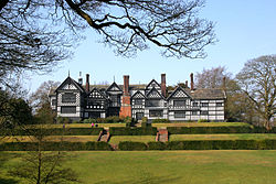
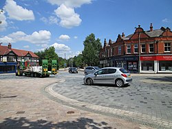
Poynton is a town in the civil parish of Poynton-with-Worth, in the Cheshire East district and the ceremonial county of Cheshire, England; from 1974 to 2009 it was in Macclesfield district. It is located on the easternmost fringe of the Cheshire Plain, 11 miles (18 km) south-east of Manchester, 7 miles (11 km) north of Macclesfield and 5 miles (8 km) south of Stockport. The first mention of the manor of Poynton was in 1289. Coal was mined in Poynton from the 16th century and the collieries, under the ownership of the Lords Vernon from 1832 until their closure in 1935, were the largest in Cheshire. Consequent urbanisation and socioeconomic development necessitated better transport links; these came with the completion of the Macclesfield Canal through Poynton in 1831, the arrival of the Manchester and Birmingham Railway in 1845 and the Macclesfield, Bollington and Marple Railway in 1869. In the late 20th century, Poynton became a commuter town for Manchester. Since 1945, the population has nearly trebled to 14,260 in 2011.

Lieux à Proximité Voir Menu
Location Image
380 m

Poynton

Poynton est une localité d'Angleterre située dans le comté de Cheshire. C'est dans cette ville qu'est censée se dérouler la série Sex Education (selon la sérigraphie d'un bus visible dans l'épisode 03 de la deuxième saison)
Location Image
2.2 km

Spotland Stadium

Spotland Stadium connu également sous le nom Crown Oil Arena pour des raisons de sponsoring, est un stade de football et de rugby à XIII situé à Rochdale. C'est le stade de l'équipe de football de Rochdale AFC et du club de rugby des Rochdale Hornets. Sa capacité actuelle est de 10 249 places. Cette enceinte sportive a été inaugurée en 1878.
2.3 km

Hazel Grove (circonscription britannique)

La circonscription de Hazel Grove est une circonscription située dans le Grand Manchester. Elle est représentée à la Chambre des communes du Parlement britannique depuis 2015 par William Wragg du Parti conservateur.
Location Image
2.9 km

Woodford (Grand Manchester)

Woodford est un village périurbain situé à la bordure sud du district métropolitain de Stockport, dans le Grand Manchester, en Angleterre. Il est situé à 8,4 km au sud de Stockport, 9,2 km au nord-ouest de Macclesfield et à 17,2 km au sud-sud-est de Manchester. Portail de Manchester et de son comté
Location Image
3.3 km

Bramhall

Bramhall est une ville située dans le district métropolitain de Stockport, dans le sud du Grand Manchester, en Angleterre. Sa population est d'environ 25 000 habitants. Bramhall est connue pour son manoir, Bramall Hall, l'un des plus grands bâtiments du XIVe siècle dans le Cheshire.