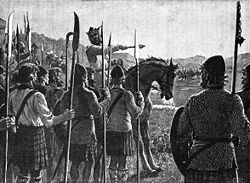
Gillies Hill is located west of Stirling and the M9, south of Cambusbarron, and north of the Bannock Burn in Central Scotland. Gillies Hill covers a 140 hectares (350 acres) crag and tail which rises from a height of 79 metres (259 ft) at the Bannock Burn Bridge near Sauchie Craig to an elevation of 162 m (531 ft) at a point which overlooks the former quarrying operation to the west and Stirling Castle to the east. The hill lies north of the Bannock Burn, northeast of Sauchie Craig (an area designated SSSI, Site of Special Scientific Interest), east of the Touch Hills and Murrayswood, south of Cambusbarron, and west of Stirling and the M9. Gillies Hill is the hill from which Robert the Bruce’s camp followers, or Gillies, descended onto the field of the Battle of Bannockburn in 1314 turning the tide of the battle which granted Scotland nearly 400 years of independence. The majority of Gillies Hill has been classified as a Semi-natural Ancient Woodland by The Woodland Trust using aerial surveys and by a follow-up Phase 1 habitat survey conducted in 2010. To date 21 Scotland & 38 United Kingdom ancient woodland indicator species have been documented on the hill demonstrating that the woodland's understory and sections of its tree cover have been cloaked in woodland for centuries; the earliest mapped confirmation of trees on the site dates back to the 1580s Pont map.

Lieux à Proximité Voir Menu
Location Image
1.4 km

Cambusbarron

Cambusbarron est un village situé dans le Stirling, en Écosse.
Location Image
2.4 km

Bataille de Bannockburn

La bataille de Bannockburn est une écrasante victoire de l’armée écossaise menée par Robert Bruce sur les troupes anglaises dirigées par Édouard II d'Angleterre les 23 et 24 juin 1314 pendant la première guerre d'indépendance écossaise. Elle est marquée par l'utilisation par Robert Bruce de carrés de piquiers nommés schiltrons sur lesquels vinrent s'écraser les charges de cavalerie anglaises. Cette bataille entraîne une remise en question tactique de l'armée anglaise, ce qui aura un impact majeur sur les tactiques de combat de la guerre de Cent Ans.
Location Image
3.1 km

Stirling (ville)

Stirling (Sruighlea en écossais (gd), Stirlin ou Srivling en scots (sco)) est une cité écossaise, située dans le council area du même nom dont elle constitue le siège et dans la région de lieutenance de Stirling and Falkirk. Elle était aussi la capitale administrative de la Central Region, entre 1975 et 1996, ainsi que du district de Stirling au sein de cette région. C'est un ancien burgh, lové autour d'un château imposant et d'une vieille ville datant du Moyen Âge. C'est également un centre administratif, de commerce de détail et d'industrie légère.
3.2 km

Annfield Stadium

L'Annfield Stadium est un ancien stade de football construit en 1945 et fermé en 1993, et situé à Stirling.
Location Image
3.2 km

Église de la Sainte-Croix de Stirling

L'église de la Sainte-Croix est une église presbytérienne située dans la ville écossaise de Stirling. Appelée en anglais Church of the Holy Rude (« rude » étant un terme ancien pour « croix »), cet édifice, remarquable pour sa tour-clocher, vit se faire couronner, en 1567, un roi d'Écosse sous son exceptionnelle charpente : Jacques VI.