
 English
 Français
Euxton
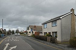
Euxton ( EKS-tən) is a village and civil parish in the Borough of Chorley, Lancashire, England. The population at the 2011 census was 9,993, but is now estimated to be around 14,000 due to housing developments in the village, including at Buckshaw. The village is just to the west of Chorley, and south of Clayton-le-Woods. Euxton covers an area around 2.5 miles (4.0 km) from east to west and 2 miles (3.2 km) north to south. The village is made up of several areas including Runshaw Moor, Balshaw, Shaw Green, Daisy Hill, Buckshaw, Pincock, Primrose Hill, Glead Hill, Dawbers, Spout Hillock, Culbeck and Pear Tree. The boundaries of Euxton have remained largely unchanged, as they follow a series of natural waterways. The northern boundary is formed by Worden Brook, which runs through the centre of Buckshaw Village and becomes Shaw Brook, marking the border between Euxton and Leyland. To the east, the boundary was historically defined by German Brook and German Lane (now Washington Lane), whereas the boundary is now broadly aligned with West Way. The southern boundary is formed by the River Yarrow, while to the west, the parish boundary follows historic field lines from Runshaw Moor southwards to the point where the A581 changes from Dawbers Lane to Southport Road near the Elephant Restaurant and on to the Yarrow. Euxton is served by five primary schools: Balshaw Lane Primary, Primrose Hill Primary, Euxton C of E Primary, Euxton RC Primary and Trinity C of E/Methodist Primary School.
Lieux à Proximité Voir Menu

Euxton

Astley Village

Chorley
