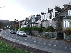
Kilmacolm ( ) is a village and civil parish in the Inverclyde council area, and the historic county of Renfrewshire in the west central Lowlands of Scotland. It lies on the northern slope of the Gryffe Valley, 7+1⁄2 miles (12 kilometres) southeast of Greenock and around 15 miles (24 km) west of the city of Glasgow. The village has a population of around 4,000 and is part of a wider civil parish which covers a large rural hinterland of 15,000 hectares (150 km2; 58 sq mi) containing within it the smaller settlement of Quarrier's Village, originally established as a 19th-century residential orphans' home. The area surrounding the village was settled in prehistoric times and emerged as part of a feudal society with the parish divided between separate estates for much of its history. The village itself remained small, providing services to nearby farm communities and acting as a religious hub for the parish. The name of the village derives from the Scottish Gaelic Cill MoCholuim, indicating the dedication of its church to St Columba. The parish church was mentioned in a papal bull of 1225 showing its appropriation to Paisley Abbey, and it sits on the site of an ancient religious community dating to the 5th or 6th centuries. Again in the 13th century, Duchal Castle was constructed in the parish and is notable for being besieged by King James IV of Scotland in 1489, following the resident Lyle family's support of an insurrection against him. Feuding between the noble families of Kilmacolm was commonplace in the Middle Ages, and in the 16th and 17th centuries, the parish again came to the attention of the Crown for providing support to outlawed religious Covenanters. The character of the village changed significantly in the Victorian era, with the arrival of the railway in Kilmacolm in 1869. Many of Kilmacolm's modern buildings were constructed between this date and the outbreak of World War I. The emergence of such transport links enabled the village to expand as an affluent dormitory village serving the nearby urban centres of Glasgow, Paisley and Greenock. The economy of the village reflected this population change, moving away from its traditional reliance on agriculture to providing tertiary sector services to residents and visitors.

Lieux à Proximité Voir Menu
Location Image
0 m

Kilmacolm

Kilmacolm est une ville et une paroisse civile d'Écosse, située dans le council area d'Inverclyde et dans la région de lieutenance du Renfrewshire. Elle est située sur le versant nord de la vallée de Strathgryfe à 12 kilomètres au sud-est de Greenock et à 24 kilomètres à l'ouest de Glasgow. La gare de Kilmacolm (en) est située sur la ligne Glasgow and South Western Railway (en). Un rapprochement est entrepris depuis mai 2014 avec la commune française de Mérignies (Nord) en vue d'un jumelage. Le hameau de Quarrier's Village fait administrativement partie de la paroisse civile de Kilmacolm.
Location Image
613 m

Windy Hill, Kilmacolm

Windy Hill ou Windyhill est une maison conçue par Charles Rennie Mackintosh et meublée par lui et sa femme, Margaret Macdonald, à Kilmacolm en Ecosse. C'est le premier projet d'habitation réalisé par Mackintosh. Elle est listée en Catégorie A des monuments classés du Royaume-Uni. Elle demeure une maison en propriété privée. Windy Hill est aussi le nom d'une colline située dans le parc régional de Clyde Muirshiel qui borde Kilmacolm.
Location Image
2.9 km

Quarrier's Village

Quarrier's Village est un village situé dans le council area d'Inverclyde et dans la région de lieutenance du Renfrewshire. Il est situé dans la vallée de Strathgryfe, entre les villages de Bridge of Weir et de Kilmacolm. Il fait d'ailleurs administrativement partie de la paroisse civile de Kilmacolm. Devenu maintenant une ville-dortoir, le village est d'origine récente, construit au XIXe siècle par la philanthrope William Quarrier (en) sous le nom de Orphans Homes of Scotland, dans le but originel d'y accueillir des orphelins. Les terrains d'entraînement du club de football de Greenock Morton sont situés dans le village. Portail de l’Écosse
Location Image
3.8 km

Strathgryfe

Strathgryffe ou Gryffe Valley (parfois orthographié Gryfe) (gaélique écossais: Srath Ghriobhaidh) est une région situé aux alentours de la Gryfe, qui s'étend sur les council area du Renfrewshire et de l'Inverclyde au Royaume-Uni. Strathgryffe a été par le passé une région et une seigneurie féodale d'Écosse.
Location Image
4.2 km

Langbank

Langbank est un village d'Écosse, situé dans le council area et région de lieutenance du Renfrewshire, et plus précisément, sur la rive sud de la Clyde. Le village possède une gare (en) depuis le 29 mars 1841 et est situé à proximité de la M8. Aujourd'hui, Langbank est un village-dortoir pour les villes de Paisley, Port Glasgow et Glasgow. Portail de l’Écosse