
 English
 Français

Astley, Greater Manchester
Astley is a village in the Metropolitan Borough of Wigan, Greater Manchester, England. Within the boundaries of the historic county of Lancashire, it is crossed by the Bridgewater Canal and the A580 East Lancashire Road. Continuous with Tyldesley, it is between Wigan and Manchester, both 8 miles (13 km) away. Astley Mosley Common ward had a population of 11,270 at the 2011 Census. Astley's name is Old English, indicating Anglo-Saxon settlement. It means either "east (of) Leigh", or ēastlēah the "eastern wood or clearing". Throughout the Middle Ages, Astley constituted a township within the parish of Leigh and hundred of West Derby. Astley appears in written form as Asteleghe in 1210, when its lord of the manor granted land to the religious order of Premonstratensian canons at Cockersand Abbey. Medieval and Early Modern Astley is distinguished by the dignitaries who occupied Damhouse, the local manor house around which a settlement expanded. The Bridgewater Canal reached Astley in 1795, and the Liverpool and Manchester Railway in 1830. The Industrial Revolution introduced the factory system when the village's cotton mill was built in 1833. Coal mining became an important industry. Mining subsidence and a decline in coal production led to a reduction in the industry in the mid-20th century; its cotton mill closed in 1955, and the last coal was brought to the surface in 1970. Astley Green Colliery Museum houses collections of Astley's industrial heritage.
Lieux à Proximité Voir Menu
Astley (Grand Manchester)
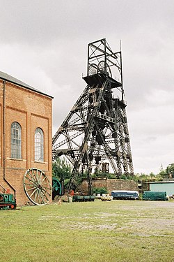
Musée de la mine d'Astley Green
Bedford (Grand Manchester)
