
 English
 Français
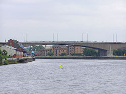
Glasgow Inner Ring Road
The Glasgow Inner Ring Road is a partially completed ring road encircling the city centre of Glasgow, Scotland. Its construction began in 1965, and half of its length was completed by 1972, forming part of the M8 motorway, but no further construction was made and the remaining plans were formally abandoned in 1980. After 30 years, a route following roughly the southern section of the proposals was created as the new M74.
Lieux à Proximité Voir Menu
615 m
Celtic Park (1888-1892)
Le Celtic Park était un terrain de football à Glasgow, en Écosse. C'était le premier domicile du Celtic FC de 1888 jusqu'à son déménagement sur le site du nouveau Celtic Park en 1892.
629 m
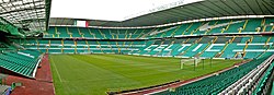
Celtic Park
Le Celtic Park est un stade de football, situé à Glasgow (Écosse), résidence du Celtic FC depuis 1892. Il peut accueillir 60 411 spectateurs.

826 m
Parkhead
Parkhead est un quartier de la ville de Glasgow, situé dans le East End (en français : « à l'est »).
Son nom vient de celui d'un ancien hameau spécialisé dans le textile. La Great Eastern Road, la Westmuir Street, la Duke Street (en) et la Springfield Road se rencontrent à Parkhead Cross, le carrefour au cœur du quartier.
Le quartier donne parfois son nom au Celtic Park, le stade du Celtic Football Club, un des deux principaux clubs d'Écosse.
937 m
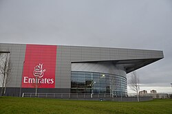
Commonwealth Arena and Sir Chris Hoy Velodrome
Le Commonwealth Arena and Sir Chris Hoy Velodrome, également appelé Emirates Arena, est une aréna et un vélodrome situé dans le quartier de Dalmarnock (en) à Glasgow en Écosse.
Construit pour les Jeux du Commonwealth de 2014, il en a accueilli les compétitions de badminton et de cyclisme sur piste. Sportscotland (en) et Scottish Cycling (en) y ont leur siège.

999 m
Dennistoun
Dennistoun est un district essentiellement résidentiel de la ville de Glasgow, au nord du fleuve Clyde et à environ 2 km du centre.
La population était d'environ 10 530 habitants en 2004.