
 English
 Français
The Portgate was a fortified gateway, constructed as part of Hadrian's Wall where it crossed the Roman road now known as Dere Street, which preceded Hadrian's Wall by around 50 years. It was built to control traffic along Dere Street as it passed north through Hadrian's Wall. The gate's remains exist beneath the old B6318 Military Road to the south-west of the Stagshaw Roundabout (the B6318 was diverted slightly for the construction of the Stagshaw Roundabout, leaving two short sections of the existing road unlinked – the remains of the Portgate are buried beneath the western section).
Lieux à Proximité Voir Menu

1.5 km
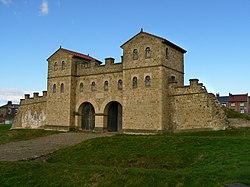
Halton (Northumberland)
Halton est une ancienne paroisse civile et un village du Northumberland, en Angleterre.

2.5 km
Sandhoe
Sandhoe est une paroisse civile et un hameau du Northumberland, en Angleterre. La population de la paroisse civile au recensement de 2011 était de 519 habitants.

2.8 km
Château d'Aydon
Le château d'Aydon est un manoir situé à Aydon, près de la ville de Corbridge, dans le comté de Northumberland, au nord-est de l'Angleterre. Il a été classé par l'English Heritage en Grade I.
3.5 km
Aydon
Aydon est un village du Northumberland en Angleterre, situé à environ 3 km au nord-est de Corbridge et à 29 km de Newcastle upon Tyne.

4.2 km
Corbridge
Corbridge est un village du Northumberland, en Angleterre, situé à 26 kilomètres à l'ouest de Newcastle et à 6 kilomètres à l'est de Hexham.