
 English
 Français
Ryedale District
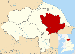
Ryedale was a non-metropolitan district in North Yorkshire, England. It was in the Vale of Pickering, a low-lying flat area of land drained by the River Derwent. The Vale's landscape is rural with scattered villages and towns. It has been inhabited continuously from the Mesolithic period. The economy was largely agricultural with light industry and tourism playing an increasing role. Towns included Helmsley, Kirkbymoorside, Malton, Norton-on-Derwent, and Pickering. Part of Ryedale lies within the North York Moors National Park. The A64 passed through Ryedale and villages such as Rillington. In the 2011 Census, the population of this primarily rural area of 150,659 hectares, the largest district in North Yorkshire, was 51,700.
Lieux à Proximité Voir Menu

0 m
Ryedale
Ryedale est un ancien district non métropolitain du Yorkshire du Nord, en Angleterre, au Royaume-Uni, dont le siège était Malton. Il a existé de 1974 à 2023.

130 m
Malton
Malton est une ville et une paroisse civile du comté du Yorkshire du Nord en Angleterre. Au recensement de 2011, la population était de 4 888 habitants et au recensement de 2021, la population comptait 6 236 habitants.

902 m
Norton-on-Derwent
Norton-on-Derwent est une ville et une paroisse civile du Yorkshire du Nord, en Angleterre.

2.5 km
Broughton (Ryedale)
Broughton est un village et une paroisse civile du Yorkshire du Nord, en Angleterre.

3.4 km
Swinton (Ryedale)
Swinton est un village et une paroisse civile du Yorkshire du Nord, en Angleterre.