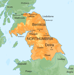
Northumbria was an early medieval English kingdom, existing between 654 and 1066 AD, spanning modern-day Northern England and Southern Scotland. The name derives from the Old English Norþhymbre meaning "the people or province north of the Humber", as opposed to the people south of the Humber Estuary. What was to become Northumbria started as two kingdoms, Deira in the south and Bernicia in the north. Conflict in the first half of the seventh century ended with the murder of the last king of Deira in 651, and Northumbria was thereafter unified under Bernician kings. At its height, the kingdom extended from the Humber, Peak District and the River Mersey on the south to the Firth of Forth on the north. Northumbria ceased to be an independent kingdom in the mid-tenth century when Deira was conquered by the Danes and formed into the Kingdom of York. The rump Earldom of Bamburgh maintained control of Bernicia for a period of time; however, the area north of the Tweed was eventually absorbed into the medieval Kingdom of Scotland while the portion south of the Tweed was absorbed into the Kingdom of England as the county of Northumberland and County Palatine of Durham.

Lieux à Proximité Voir Menu
Location Image
0 m

Gododdin

Le Gododdin [ɡoˈdoðin] était un des royaumes bretons du nord de l'île de Bretagne (Hen Ogledd & Northumbrie), au nord du mur d'Hadrien et, partiellement, au sud du mur d'Antonin, qui s'était constitué après le départ des troupes romaines.
Location Image
2.4 km

Château de Thirlwall

Le château de Thirlwall est un château du XIIe siècle situé dans le Northumberland, en Angleterre, sur la rive de la rivière Tipalt, près du village de Greenhead et à environ 20 milles à l'ouest d'Hexham. Il est construit au XIIe siècle, puis renforcé à l'aide de pierres provenant du mur d'Hadrien voisin, mais commence à tomber en ruine au XVIIe siècle. Le site est protégé par le statut de bâtiment classé de catégorie I.
Location Image
2.4 km

Greenhead (Northumberland)

Greenhead est une paroisse civile et un village du Northumberland, en Angleterre.
Location Image
4.3 km

Haltwhistle

Haltwhistle est une petite ville et une paroisse civile dans le comté de Northumberland, en Angleterre. Elle est située à 16 km à l'est de Brampton, près du mur d'Hadrien, et des villages de Plenmeller, Rowfoot et Melkridge. Il y a, non loin de là, le site du camp romain d'Aesica. Haltwhistle est desservie par le train depuis 1835, ce qui permet son essor industriel. Comptant des mines de charbon et de plomb, elle s'est ensuite reconvertie dans l'industrie chimique, de plasturgie et de peinture. Le liquide antigel des avions y est notamment fabriqué. En 1994, un habitant de Haltwhistle établit à partir de calculs que le centre géographique de la Grande-Bretagne se trouve à Haltwhistle, baptisant son hôtel Centre of Britain, dans une maison fortifiée du XVe siècle, bâtie pour résister aux raids des clans anglo-écossais des Reivers. La ville s'enorgueillit depuis de ce titre, notamment pour des raisons touristiques. Cependant, au début des années 2000, un Australien a établi le centre de la Grande-Bretagne à Hinckley, à 350 km de là.
Location Image
4.8 km

Château de Bellister

Le château de Bellister est un manoir crénelé du XIXe siècle appartenant au National Trust, attaché aux vestiges en ruine d'une maison-tour du XIVe siècle, près de Haltwhistle, dans le Northumberland, en Angleterre. Il s'agit d'un monument ancien classé et d'un bâtiment classé Grade I.