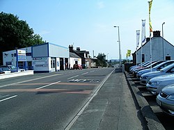
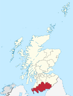
Torthorwald is a village and civil parish in Dumfries and Galloway, south-west Scotland. It is located 6 kilometres (3.7 mi) east of Dumfries on the A709 road to Lochmaben. The area was the property of the de Torthorwald family until the end of the 13th century, when the estate passed by marriage to the Kirkpatricks. In 1418, William de Carleil married the Kirkpatrick heiress. He may have been the builder of Torthorwald Castle, which was erected around this time, possibly on top of an earlier a motte. Torthorwald was erected as a burgh of barony in 1473. Torthorwald Castle was occupied until 1715; only two of its walls still stand, to a height of around 18 metres (59 ft). The pre-Reformation church at Torthorwald belonged to the Trinitarian Friars of Fail in Ayrshire. The present parish church was erected in 1782 on the site of this earlier foundation. Torthorwald is now within the united Parish of Kirkmichael, Tinwald and Torthorwald, which was created in 1981. The 19th-century missionary John Gibson Paton (1824–1907) grew up in Torthorwald. His evangelical work in the New Hebrides is commemorated in the church gate piers. Another building of interest is a 19th-century cruck-framed and thatched cottage. Restored in the 1990s, the cottage is protected as a category A listed building, and is maintained by a local heritage association. The village has a hotel, a village hall, and formerly had a primary school which closed in 2010. An annual Scarecrow Fun Day involves villagers erecting scarecrows in their front gardens.

Lieux à Proximité Voir Menu
Location Image
1 m

Torthorwald

Torthorwald est un village situé dans le Dumfries and Galloway, en Écosse.
Location Image
4.5 km

Locharbriggs

Locharbriggs est un village situé dans le Dumfries and Galloway, en Écosse.
Location Image
5.6 km

Amisfield

Amisfield est un village situé dans le Dumfries and Galloway, en Écosse.
Location Image
6.0 km

Dumfries and Galloway

Le Dumfries and Galloway est une council area et une ancienne région d'Écosse, qui couvre la partie ouest des Southern Uplands, dans le sud de l'Écosse, avec pour siège la ville de Dumfries. C'est une région de collines et de prairies avec des exploitations agricoles rentables. Le Galloway Forest Park est pratiquement le seul endroit d'Écosse où la forêt a été réimplantée à grande échelle. La presqu'île des Rhinns of Galloway, au sud-ouest, est plus tournée vers la mer. Stranraer est le port d'où l'on embarque pour l'Irlande du Nord. Le rivage est par endroits constitué de falaises impressionnantes où les vagues viennent se briser les jours de mer forte. Le point le plus au sud de l'Écosse, le Mull of Galloway se trouve dans le district, plus précisément dans le Wigtownshire. Dumfries (env. 32 000 habitants) est un centre de tourisme où le souvenir du poète Robert Burns est très présent. La circonscription administrative régionale a été créée le 15 mai 1975 par la fusion de trois comtés traditionnels : le Dumfriesshire, le Kirkcudbrightshire (aussi connu comme le Stewartry of Kirkcudbright) et le Wigtownshire. Les deux derniers comtés formaient la région historique de Galloway. La région a existé jusqu'au 31 mars 1996 où elle fut remplacée par un council area qui recouvre exactement la même zone géographique. Quand elle était une région, elle était divisée en 4 districts :
6.4 km

Bataille de Lochmaben Fair

La bataille de Lochmaben Fair oppose les partisans du roi d'Écosse Jacques III et des rebelles conduits par le duc d'Albany et le comte de Douglas.