
 English
 Français
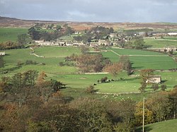
Coverdale, North Yorkshire
Coverdale is a dale in the far east of the Yorkshire Dales, North Yorkshire, England. It takes its name from the River Cover, a tributary of the River Ure. The dale runs south-west from the eastern end of Wensleydale to the dale head at a pass, known as Park Rash Pass, between Great Whernside to the south and Buckden Pike to the north. It is accessible by a single track road, which runs the length of the dale and over the pass to Kettlewell in Wharfedale. The name is taken from that of the River Cover, which is of Brittonic origin. Ekwall suggested that it might mean "hollow stream", but more recently Andrew Breeze has argued that it is cognate with Welsh gofer "streamlet".
Lieux à Proximité Voir Menu

885 m
Carlton (Richmondshire)
Carlton est un village et une paroisse civile du Yorkshire du Nord, en Angleterre.

899 m
West Scrafton
West Scrafton est un village et une paroisse civile du Yorkshire du Nord, en Angleterre.

1.8 km
Melmerby (Richmondshire)
Melmerby est un village et une paroisse civile du Yorkshire du Nord, en Angleterre.

3.1 km
Caldbergh with East Scrafton
Caldbergh with East Scrafton est une paroisse civile du Yorkshire du Nord, en Angleterre.

3.4 km
Coverham with Agglethorpe
Coverham with Agglethorpe est une paroisse civile du Yorkshire du Nord, en Angleterre.