English
 Français

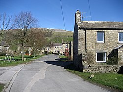
Keld, North Yorkshire
Keld is a village in the English county of North Yorkshire. It is in Swaledale, and the Yorkshire Dales National Park. The name derives from the Viking word Kelda meaning a spring and the village was once called Appletre Kelde – the spring near the apple trees. From 1974 to 2023 it was part of the district of Richmondshire, it is now administered by the unitary North Yorkshire Council. Keld is the crossing point of the Coast to Coast Walk and the Pennine Way long-distance footpaths at the head of Swaledale, and marks the end of the Swale Trail, a 20 km mountain bike trail which starts in Reeth. At the height of the lead-mining industry in Swaledale in the late 19th century, several notable buildings – now Grade II listed – were erected: they include the Congregational and Methodist chapels, the school and Keld Literary Institute. A tea room and small shop operate at Park Lodge from Easter to autumn. Out of season, local volunteers provide a self service café for visitors in the village’s Public Hall. Keld’s Youth Hostel closed in 2008 and has since reopened as Keld Lodge, a hotel with bar and restaurant. There is a series of four waterfalls close to Keld in a limestone gorge on the River Swale: Kisdon Force, East Gill Force, Catrake Force and Wain Wath Force.
Lieux à Proximité Voir Menu