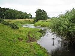
The River Wansbeck runs through the county of Northumberland, England. It rises above Sweethope Lough on the edge of Fourlaws Forest in the area known locally as The Wanneys (Great Wanney Crag, Little Wanney Crag; thus the "Wanneys Beck"); runs through the town of Ashington before discharging into the North Sea at Sandy Bay near Newbiggin-by-the-Sea. The River flows through the village of Kirkwhelpington, Hartburn, where the tributary Hart Burn joins, the village of Mitford, where the River Font joins, and the town of Morpeth. The River Wansbeck is nicknamed the River Wanney. The term 'The Wilds of Wanney' is used by people of Tyneside to refer to the rural areas of Northumberland where the Wansbeck rises. The River lent its name to the former Wansbeck district which was based in Ashington, and included Newbiggin-by-the-Sea, Bedlington and Stakeford. Castle Island is an ait of the River Wansbeck.

Lieux à Proximité Voir Menu
Location Image
2.5 km

Newbiggin-by-the-Sea

Newbiggin-by-the-Sea est une ville balnéaire et une paroisse civile du Northumberland, en Angleterre.
Location Image
2.9 km

Wansbeck

Wansbeck est un ancien district non-métropolitain du Northumberland, en Angleterre. Il doit son nom à la rivière Wansbeck. Il a été créé le 1er avril 1974 par le Local Government Act de 1972 et est issu de la fusion des districts urbains de Ashington, Bedlingtonshire et Newbiggin-by-the-Sea. Ses principales villes sont Ashington, où siégeait le conseil de district, Bedlington et Newbiggin-by-the-Sea. Il se trouve au bord de la mer du Nord, au nord de la conurbation de Tyneside. Le conseil de district a été aboli par les changements structurels de l'administration locale anglaise de 2009, entrés en vigueur le 1er avril 2009. Ses pouvoirs ont été transférés au conseil de comté du Northumberland, agissant en tant qu'autorité unitaire.
Location Image
3.2 km

Ashington

Ashington est une banlieue anglaise située à Newcastle-upon-Tyne dans le comté du Northumberland au nord du pays. En 2011, sa population était de 27 769 habitants.
Location Image
3.9 km

Blyth Valley

La Blyth Valley est un ancien district non-métropolitain et un Borough du Northumberland, en Angleterre. Il est situé au bord de la mer du Nord et jouxte le comté de Tyne and Wear. Il a été créé le 1er avril 1974 par le Local Government Act de 1972 et est issu de la fusion du borough de Blyth, du district urbain de Seaton Valley, et d'une partie du borough de Whitley Bay. Il comprend notamment les villes de Blyth, où siège le conseil de district, et Cramlington, et les localités de Seaton Delaval et Seaton Sluice. Le conseil de district a été aboli par les changements structurels de l'administration locale anglaise de 2009, entrés en vigueur le 1er avril 2009. Ses pouvoirs ont été transférés au conseil de comté du Northumberland, agissant en tant qu'autorité unitaire.
Location Image
4.1 km

Blyth (Northumberland)

Blyth est une ville du sud du comté de Northumberland en Angleterre. Elle se trouve à une vingtaine de kilomètres de Newcastle upon Tyne. Le développement de la ville moderne a commencé dans le premier quart du XVIIIe siècle. Les principales industries qui ont contribué à la prospérité de la ville étaient l'extraction du charbon et la construction navale. Ces industries ont largement disparu, mais le port continue de prospérer. Son cartulaire a été conservé. Les importants personnages de la région au Moyen Âge s'y trouvent cités. Parmi eux, on note la présence de William de Wendeval dont le nom est sur la liste des inspirateurs du personnage du Shérif de Nottingham, dans la légende de Robin des Bois. Elle possède un ancien phare construit en 1788 connu sous le nom de High Light.