
 English
 Français
Grasmoor
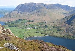
Grasmoor is a mountain in the north-western part of the Lake District, northern England. It is the highest peak in a group of hills between the villages of Lorton, Braithwaite and Buttermere, and overlooks Crummock Water. Grasmoor is distinguished by its steep western flank, dropping dramatically to Crummock Water. This face is however not suitable for rock climbers as there is little clean rock, although Alfred Wainwright describes a challenging route up the face in his Pictorial Guides to the Lakeland Fells. To the east the fell is linked to others by Crag Hill and Coledale Hause. Grasmoor is also home to the most extensive scree slopes in the North Western Fells.
Lieux à Proximité Voir Menu

3.3 km
Loweswater
Loweswater est un village et une paroisse civile de Cumbria, situé dans le nord-ouest de l'Angleterre.

3.3 km
Buttermere (Cumbria)
Buttermere est un village et une paroisse civile de Cumbria, situé dans le nord-ouest de l'Angleterre.

4.3 km
Lac Buttermere
Le lac Buttermere est un lac du parc national du Lake District en Cumbria, au Royaume-Uni.

5.1 km
Lorton (Cumbria)
Lorton est une paroisse civile de Cumbria, située dans le nord-ouest de l'Angleterre.
5.2 km
Above Derwent
Above Derwent est une paroisse civile de Cumbria, située dans le nord-ouest de l'Angleterre.