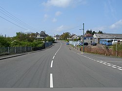
Luggiebank is a small village to the south of Cumbernauld. Like Condorrat, Castlecary and Dullatur, it predates the new town of Cumbernauld, and of those, only Condorrat was officially included in the designated area. It is situated on what used to be the Stirling Road from Lanark, but as a result of a bypass (B8039) the old road is now a cul-de-sac. Unlike the rest of Cumbernauld, which was in Dunbartonshire, Luggiebank was historically in Lanarkshire, but was adopted into Dunbartonshire in 1967, prior to Cumbernauld becoming a police burgh the following year. Following further boundary changes in 1995, Luggiebank became part of North Lanarkshire.

The village consists of around 30 houses and is essentially built around two streets: the older part of Stirling Road and newer houses on Blairlinn View, named after the farmsteads of Wester, Mid and Easter Blairlinn. Other farms and houses in the surrounding area are deemed to be in Luggiebank. On the south bound side of Stirling Road the houses back onto Luggie Water. The associated glen is now a nature reserve managed by the Scottish Wildlife Trust. The name comes from a cottage of that name which appears on the first Edition of the Ordnance Survey. In a Scots dictionary, luggie can mean a wooden bucket with handles. An extract from the Ordnance Gazetteer of Scotland 1882 describes The Luggie in less than glowing terms. Two poems by Victorian poet David Gray fondly reminisce upon The Luggie: 'The Dear Old Toiling One' and 'The Luggie'. The historical village houses are displayed on the north bound side of Stirling Road in the 1864 Ordnance Survey map. People used to go on holiday in the village and there is a postcard looking south, showing the village possibly from the 1930s. The Luggie Bridge, just to the north of the village, is a stone arch that now forms part of the foot way north out of the village.

Lieux à Proximité Voir Menu
Location Image
2.0 km

Cumbernauld

Cumbernauld (Comar nan Allt en gaélique écossais (gd)) est une ville nouvelle d'Écosse, située dans le council area du North Lanarkshire et dans la région de lieutenance et ancien comté du Dunbartonshire. De 1975 à 1996, elle était la capitale administrative du district de Cumbernauld and Kilsyth (originellement appelé Cumbernauld), au sein de la région du Strathclyde. Elle se trouve dans la Central Belt à environ 21 km à l'est de Glasgow et à 60 km à l'ouest d'Édimbourg. Son nom est d'origine gaelique (comar nan allt), qui signifie "la rencontre des eaux". En effet, Cumbernauld se trouve entre les fleuves Clyde et Forth. Sa population est d'environ 50 000 habitants en 2000.
Location Image
2.7 km

Wattston

Wattston est un village situé dans le North Lanarkshire, en Écosse.
Location Image
2.8 km

Greengairs

Greengairs est un village situé dans le North Lanarkshire, en Écosse.
Location Image
3.4 km

Cumbernauld House

Cumbernauld House est une maison de campagne écossaise du XVIIIe siècle située à Cumbernauld, en Écosse. La maison est située sur le site de (l'ancien) château de Cumbernauld, assiégé par le général Monck en 1651. Elle est construite en 1731 selon les plans de William Adam (1689–1748), pour John Fleming, 6e comte de Wigtown. À la fin du XXe siècle, la maison est utilisée comme bureaux, d'abord par la Cumbernauld Development Corporation, puis le North Lanarkshire Council, et enfin par DH Morris, qui est mis en liquidation en mars 2007. Le bâtiment reste vide pendant une décennie jusqu'à ce qu'il soit transformé en appartements de luxe. Cumbernauld House est un bâtiment classé de catégorie A.
Location Image
4.1 km

Broadwood Stadium

Le Broadwood Stadium (couramment appelé Broadwood) est un stade multifonction construit en 1994 et situé à Cumbernauld. D'une capacité de 8 029 places toutes assises, il accueille depuis sa création les matches à domicile du Clyde FC, club du championnat écossais, mais aussi, plus récemment, des Cumbernauld Colts (en), équipe de Lowland Football League, ainsi que de la Scottish Rugby Academy, West (en).