
 English
 Français

South Newbald
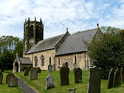
South Newbald is a hamlet and former civil parish, now in the parish of Newbald, in the East Riding of Yorkshire, England. It is situated approximately 12 miles (19 km) north-west of Hull city centre, 2.5 miles (4 km) north of South Cave and 4 miles (6.4 km) south of Market Weighton. It lies to the east of the A1034 road. The larger village of North Newbald is just to the north. In 1931 the parish had a population of 173. In 1823 South Newbald was in the civil parish of North Newbald, the Wapentake of Harthill and the Liberty of St Peter's. Population at the time was 179, with occupations including seven farmers & yeomen and three corn millers. Resident was a banker, an overseer, and the vicar of North Newbald. The name Newbald derives from the Old English nīwebōðl meaning 'new dwelling'.
Lieux à Proximité Voir Menu

Newbald

Hotham (Yorkshire de l'Est)
Sancton

North Cave
