
 English
 Français

Daer Reservoir
Daer Reservoir is a man-made waterbody created by the damming of the Daer Water, a tributary of the River Clyde in the Southern Uplands of Scotland. It lies within the Lowther Hills in South Lanarkshire. It is accessible by a minor public road leaving the A702 follows the Daer Water south to the dam and then continues along the western margin of the reservoir as far as Kirkhope. The reservoir was officially opened by Elizabeth II in 1956 to supply water to the Scottish Central Belt.
Lieux à Proximité Voir Menu

9.0 km
9.9 km
Annanhead
Annanhead ou Annanhead Hill est un sommet de 478 mètres d'altitude situé dans les Moffat Hills (en), en Écosse. Il se trouve à la frontière entre les Scottish Borders et le Dumfries and Galloway, à 9 kilomètres au nord de Moffat, dans les Southern Uplands.
Annanhead est l'une des quatre collines entourant le Devil's Beef Tub, source du fleuve Annan.
La colline est traversée par le sentier de randonnée Annandale Way (en).

10.1 km
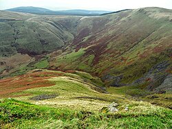
Devil's Beef Tub
Le Devil's Beef Tub est une vallée de 150 m de profondeur en Écosse au nord de Moffat. Elle est entourée de quatre collines : Great Hill (465 m), Peat Knowe, Annanhead Hill et Ericstane Hill.

10.5 km
Tweed (fleuve)
La Tweed est le troisième fleuve d’Écosse avec ses 156 km de longueur, après la Tay et la Clyde.

11.6 km