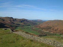
Burnmoor Tarn, on Eskdale Fell in Cumbria, England, is the largest entirely natural tarns in the Lake District. Its waters flow into Whillan Beck at the tarn's north-eastern corner, which immediately turns south and flows into Eskdale, joining the Esk at Beckfoot. Burnmoor Lodge, a former fishing lodge, stands by the southern shore and a mediaeval corpse road runs past the eastern shore where it fords the beck. Eskdale Moor or Boat How lies to the south of the tarn. The tarn is one of the sites in DEFRA's UK Upland Waters Monitoring Network. It occupies 23.9 hectares (59 acres) and lies at an altitude of 253 metres (830 ft) in a moraine hollow on the uplands between Wastwater and Eskdale. The lake has two distinct basins close to the south-eastern shore and a maximum depth of 13 metres (43 ft). There are four main inflow streams to the north and north-west. The outflow at the eastern end joins the Hardrigg Beck which drains the slopes of Scafell and, in times of especially high flow, is partly diverted into the lake across a braided delta.

Lieux à Proximité Voir Menu
Location Image
2.6 km

Wast Water

Le Wast Water est un lac anglais situé à Wasdale, dans le Lake District dans le comté de Cumbria. Il est le lac le plus profond d'Angleterre avec à 79 m de profondeur.
Location Image
3.1 km

Scafell

Le Scafell, ou Sca Fell (anciennement Scawfell), est avec 964 mètres d'altitude le deuxième plus haut sommet de l'Angleterre et des Southern Fells, après Scafell Pike. Il est constitué de roches magmatiques. Il se trouve dans le Lake District, au sein du parc national du même nom, en Cumbria.
Location Image
4.1 km

Eskdale (Cumbria)

Eskdale est une vallée et une paroisse civile de Cumbria, située dans le nord-ouest de l'Angleterre.
Location Image
4.3 km

Scafell Pike

Scafell Pike est un sommet du Royaume-Uni dont l'altitude de 978 mètres en fait le point culminant de l'Angleterre et des Southern Fells. Il est constitué de roches magmatiques. Il se trouve dans le Lake District, au sein du parc national du même nom, en Cumbria. Le poète Robert Southey aurait réalisé sa première ascension en 1802. La montagne appartient au National Trust. C'est un lieu de randonnée pédestre très fréquenté mais aussi un important site d'escalade.
Location Image
4.5 km

Mediobogdum

Mediobogdum, appelé aujourd’hui fort romain de Hardknott, est un ancien fort romain de la province de Britannia, qui gardait le col de Hardknott, dominant la rivière britannique Esk, dans le comté anglais de Cumbria. Ses ruines font partie des propriétés de l’English Heritage.